
Parque Los Dinamos topographic map
Interactive map
Click on the map to display elevation.
About this map
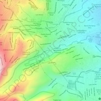
Name: Parque Los Dinamos topographic map, elevation, terrain.
Average elevation: 8,507 ft
Minimum elevation: 8,081 ft
Maximum elevation: 9,206 ft
Other topographic maps
Click on a map to view its topography, its elevation and its terrain.
Segundo y Tercer Dinamos
Segundo y Tercer Dinamos, La Magdalena Contreras, Santa Fe, Mexico City, 10643, Mexico
Average elevation: 9,711 ft
Miguel Hidalgo
Miguel Hidalgo, Santa Fe, Mexico City, 05348, Mexico
Average elevation: 7,467 ft