
Bình Liêu District topographic map
Interactive map
Click on the map to display elevation.
About this map
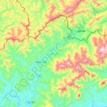
Name: Bình Liêu District topographic map, elevation, terrain.
Location: Bình Liêu District, Quảng Ninh Province, Vietnam (21.43765 107.27310 21.66353 107.61271)
Average elevation: 1,526 ft
Minimum elevation: 69 ft
Maximum elevation: 4,760 ft
Other topographic maps
Click on a map to view its topography, its elevation and its terrain.
Vân Đồn District
Vân Đồn District, Quảng Ninh Province, 02000, Vietnam
Average elevation: 82 ft
Ha Long
Vietnam > Quang Ninh Province > Ha Long
Ha Long, Hạ Long City, Quang Ninh Province, 36000, Vietnam
Average elevation: 180 ft
Hạ Long City
Hạ Long City, Quang Ninh Province, 36000, Vietnam
Average elevation: 318 ft