
Fenland topographic map
Interactive map
Click on the map to display elevation.
About this map
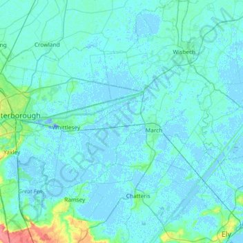
Name: Fenland topographic map, elevation, terrain.
Average elevation: 13 ft
Minimum elevation: -59 ft
Maximum elevation: 177 ft
Other topographic maps
Click on a map to view its topography, its elevation and its terrain.
Wisbech St. Mary
United Kingdom > England > Cambridgeshire > Fenland > Murrow
Wisbech St. Mary, Murrow, Fenland, Cambridgeshire, East of England, England, United Kingdom
Average elevation: 3 ft
Wisbech and Upwell Tramway
United Kingdom > England > Cambridgeshire > Fenland > Friday Bridge
Wisbech and Upwell Tramway, March Road, Elm, Friday Bridge, Fenland, Cambridgeshire, East of England, England, PE14 0HF, United Kingdom
Average elevation: 10 ft