
El Marqués topographic map
Interactive map
Click on the map to display elevation.
About this map
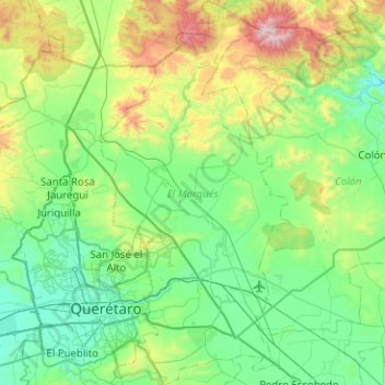
Name: El Marqués topographic map, elevation, terrain.
Location: El Marqués, Querétaro, Mexico (20.50093 -100.40724 20.97100 -100.15491)
Average elevation: 6,860 ft
Minimum elevation: 5,689 ft
Maximum elevation: 10,958 ft
Other topographic maps
Click on a map to view its topography, its elevation and its terrain.
La Laborcilla
Mexico > Querétaro > El Marqués
La Laborcilla, El Marqués, Querétaro, Mexico
Average elevation: 7,579 ft
San José Navajas
Mexico > Querétaro > El Marqués
San José Navajas, El Marqués, Querétaro, 76278, Mexico
Average elevation: 6,319 ft