
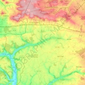
Couëtron-au-Perche topographic map
Interactive map
Click on the map to display elevation.
About this map
Name: Couëtron-au-Perche topographic map, elevation, terrain.
Average elevation: 577 ft
Minimum elevation: 325 ft
Maximum elevation: 840 ft
Other topographic maps
Click on a map to view its topography, its elevation and its terrain.
Savigny-sur-Braye
France > Centre-Val de Loire > Loir-et-Cher
Savigny-sur-Braye, Vendôme, Loir-et-Cher, Centre-Val de Loire, Metropolitan France, 41360, France
Average elevation: 423 ft
Pray
France > Centre-Val de Loire > Loir-et-Cher
Pray, Vendôme, Loir-et-Cher, Centre-Val de Loire, Metropolitan France, 41190, France
Average elevation: 417 ft
Blois
France > Centre-Val de Loire > Loir-et-Cher
Blois, Loir-et-Cher, Centre-Val de Loire, Metropolitan France, 41000, France
Average elevation: 312 ft