
Galion topographic map
Interactive map
Click on the map to display elevation.
About this map
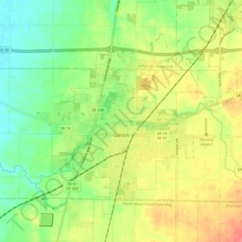
Name: Galion topographic map, elevation, terrain.
Location: Galion, Crawford County, Ohio, 44833, United States (40.70736 -82.82027 40.76963 -82.71348)
Average elevation: 1,152 ft
Minimum elevation: 1,060 ft
Maximum elevation: 1,263 ft
Other topographic maps
Click on a map to view its topography, its elevation and its terrain.
Bucyrus
United States > Ohio > Crawford County
Bucyrus, Crawford County, Ohio, 44820, United States
Average elevation: 1,007 ft
Chatfield
United States > Ohio > Crawford County
Chatfield, Chatfield Township, Crawford County, Ohio, United States
Average elevation: 988 ft
Oceola
United States > Ohio > Crawford County
Oceola, Tod Township, Crawford County, Ohio, 44860, United States
Average elevation: 955 ft
New Washington
United States > Ohio > Crawford County
New Washington, Cranberry Township, Crawford County, Ohio, United States
Average elevation: 988 ft
North Robinson
United States > Ohio > Crawford County
North Robinson, Whetstone Township, Crawford County, Ohio, 44856, United States
Average elevation: 1,063 ft
Tiro
United States > Ohio > Crawford County
Tiro, Auburn Township, Crawford County, Ohio, United States
Average elevation: 1,050 ft
Auburn Township
United States > Ohio > Crawford County
Auburn Township, Crawford County, Ohio, United States
Average elevation: 1,010 ft
Cranberry Township
United States > Ohio > Crawford County
Cranberry Township, Crawford County, Ohio, 44854, United States
Average elevation: 991 ft
Crestline
United States > Ohio > Crawford County
Crestline, Crawford County, Ohio, 44827, United States
Average elevation: 1,165 ft