
Terchová topographic map
Interactive map
Click on the map to display elevation.
About this map
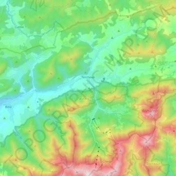
Name: Terchová topographic map, elevation, terrain.
Average elevation: 2,687 ft
Minimum elevation: 1,407 ft
Maximum elevation: 5,541 ft
The municipality lies at an altitude of 514 metres and covers an area of 84.542 km2. It has a population of about 4,073 people. The village lies in a valley in the Malá Fatra mountains, about 25 km east of Žilina. The tourist resort of Vrátna dolina belongs to the village.
Other topographic maps
Click on a map to view its topography, its elevation and its terrain.
Banát
Slovakia > Region of Žilina > District of Žilina > Rajecké Teplice
Banát, Poluvsie, Poluvsie nad Rajčankou, Rajecké Teplice, District of Žilina, Region of Žilina, Central Slovakia, 013 12, Slovakia
Average elevation: 1,680 ft
Žilina
Slovakia > Region of Žilina > District of Žilina
Žilina, District of Žilina, Region of Žilina, Central Slovakia, Slovakia
Average elevation: 1,391 ft