
Kochkor River topographic map
Interactive map
Click on the map to display elevation.
About this map
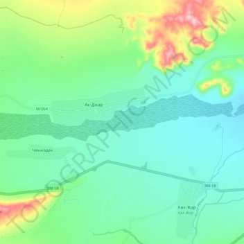
Name: Kochkor River topographic map, elevation, terrain.
Location: Kochkor River, Naryn Region, Kyrgyzstan (42.20553 75.57163 42.21475 75.67648)
Average elevation: 6,194 ft
Minimum elevation: 5,997 ft
Maximum elevation: 6,759 ft
Other topographic maps
Click on a map to view its topography, its elevation and its terrain.
Kochkor District
Kochkor District, Naryn Region, Kyrgyzstan
Average elevation: 8,514 ft
Naryn District
Naryn District, Naryn Region, 722600, Kyrgyzstan
Average elevation: 10,039 ft
At-Bashy
Kyrgyzstan > Naryn Region > At-Bashy District
At-Bashy, At-Bashy District, Naryn Region, 722620, Kyrgyzstan
Average elevation: 6,791 ft
Kochkor
Kyrgyzstan > Naryn Region > Kochkor
Kochkor, Naryn Region, 722800, Kyrgyzstan
Average elevation: 5,978 ft
Sarychat glacier
Sarychat glacier, Naryn Region, Kyrgyzstan
Average elevation: 13,835 ft
At-Bashi River
At-Bashi River, Naryn Region, 722620, Kyrgyzstan
Average elevation: 10,348 ft