
Highland Heights topographic map
Interactive map
Click on the map to display elevation.
About this map
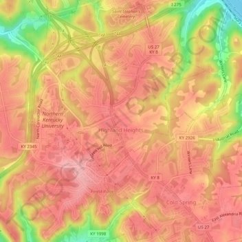
Name: Highland Heights topographic map, elevation, terrain.
Average elevation: 778 ft
Minimum elevation: 476 ft
Maximum elevation: 909 ft
Other topographic maps
Click on a map to view its topography, its elevation and its terrain.
Newport
United States > Kentucky > Campbell County
Newport, Campbell County, Kentucky, 41071, United States
Average elevation: 568 ft
Dayton
United States > Kentucky > Campbell County
Dayton, Campbell County, Kentucky, 41074, United States
Average elevation: 623 ft
Melbourne
United States > Kentucky > Campbell County
Melbourne, Campbell County, Kentucky, United States
Average elevation: 551 ft
Alexandria
United States > Kentucky > Campbell County
Alexandria, Campbell County, Kentucky, United States
Average elevation: 722 ft
Fort Thomas
United States > Kentucky > Campbell County
Fort Thomas, Campbell County, Kentucky, 41075, United States
Average elevation: 630 ft
Newport
United States > Kentucky > Campbell County > Newport
Newport, Campbell County, Kentucky, 41071-9998, United States
Average elevation: 640 ft
Cold Spring
United States > Kentucky > Campbell County
Cold Spring, Campbell County, Kentucky, 41076, United States
Average elevation: 692 ft
Wilder
United States > Kentucky > Campbell County
Wilder, Campbell County, Kentucky, United States
Average elevation: 679 ft