
Namchi topographic map
Interactive map
Click on the map to display elevation.
About this map
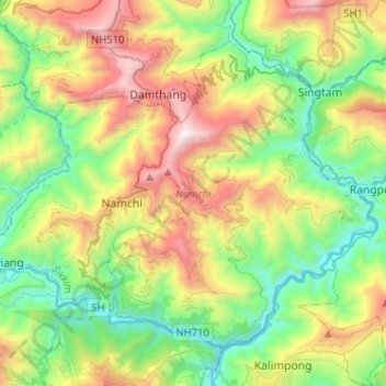
Name: Namchi topographic map, elevation, terrain.
Location: Namchi, Namchi District, Sikkim, India (27.07940 88.27785 27.26382 88.53456)
Average elevation: 3,412 ft
Minimum elevation: 669 ft
Maximum elevation: 8,586 ft
Other topographic maps
Click on a map to view its topography, its elevation and its terrain.
Lachung
India > Sikkim > Chungthang
Lachung, Chungthang, North Sikkim District, Sikkim, India
Average elevation: 11,867 ft
Katao
India > Sikkim > Chungthang
Katao, Chungthang, North Sikkim District, Sikkim, India
Average elevation: 14,780 ft
East District
India > Sikkim > East District
East District, East Sikkim District, Sikkim, India
Average elevation: 8,990 ft
Zemu Glacier
Zemu Glacier, North District, North Sikkim District, Sikkim, India
Average elevation: 18,041 ft