
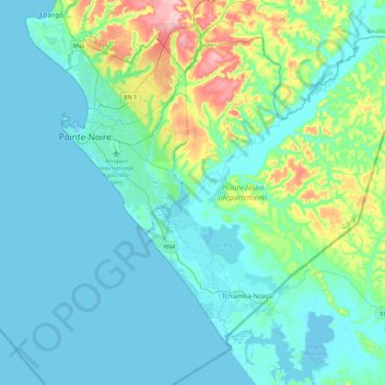
Pointe-Noire topographic map
Interactive map
Click on the map to display elevation.
About this map
Name: Pointe-Noire topographic map, elevation, terrain.
Location: Pointe-Noire, Congo-Brazzaville (-4.96576 11.62411 -4.72242 11.93255)
Average elevation: 56 ft
Minimum elevation: -7 ft
Maximum elevation: 600 ft
Other topographic maps
Click on a map to view its topography, its elevation and its terrain.
Pointe-Noire
Congo-Brazzaville > Pointe-Noire > Hinda
Pointe-Noire, Hinda, Lumumba, Pointe-Noire, Congo-Brazzaville
Average elevation: 89 ft