
Dinorwig topographic map
Interactive map
Click on the map to display elevation.
About this map
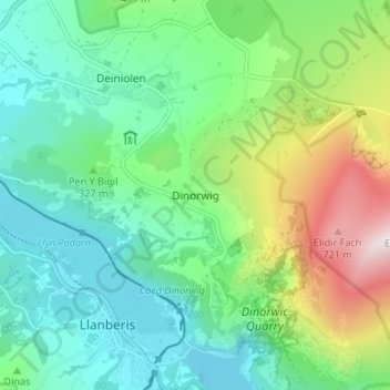
Name: Dinorwig topographic map, elevation, terrain.
Location: Dinorwig, Gwynedd, Wales, LL55 3EN, United Kingdom (53.11454 -4.13266 53.15454 -4.09266)
Average elevation: 1,027 ft
Minimum elevation: 289 ft
Maximum elevation: 2,917 ft
Other topographic maps
Click on a map to view its topography, its elevation and its terrain.
Serengeti
United Kingdom > Wales > Dinorwig
Serengeti, Dinorwig, Gwynedd, Wales, LL55 3EU, United Kingdom
Average elevation: 1,119 ft