
Banfora topographic map
Interactive map
Click on the map to display elevation.
About this map
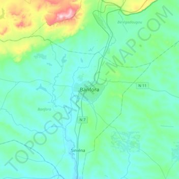
Name: Banfora topographic map, elevation, terrain.
Location: Banfora, Comoé, Waterfalls, Burkina Faso (10.48270 -4.91264 10.80270 -4.59264)
Average elevation: 1,070 ft
Minimum elevation: 853 ft
Maximum elevation: 2,310 ft
Other topographic maps
Click on a map to view its topography, its elevation and its terrain.
Bobo-Dioulasso
Bobo-Dioulasso, Houet, Upper-Basins, Burkina Faso
Average elevation: 1,273 ft
Koala
Koala, Nagréongo, Oubritenga, Central-Plateau, Burkina Faso
Average elevation: 948 ft
Koupéla
Koupéla, Sabou, Boulkiemdé, Central-West, Burkina Faso
Average elevation: 961 ft
Petebarabe
Petebarabe, Falagountou, Séno, Sahel, Burkina Faso
Average elevation: 869 ft
Fada N'Gourma
Fada N'Gourma, Gourma, East, Burkina Faso
Average elevation: 991 ft