
Poznań topographic map
Interactive map
Click on the map to display elevation.
About this map
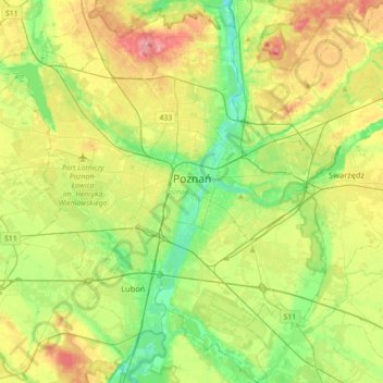
Name: Poznań topographic map, elevation, terrain.
Location: Poznań, Poznań County, Greater Poland Voivodeship, Poland (52.29192 16.73159 52.50933 17.07171)
Average elevation: 279 ft
Minimum elevation: 148 ft
Maximum elevation: 479 ft
Other topographic maps
Click on a map to view its topography, its elevation and its terrain.
Kórnik
Poland > Greater Poland Voivodeship > Poznań County
Kórnik, gmina Kórnik, Poznań County, Greater Poland Voivodeship, 62-035, Poland
Average elevation: 246 ft
Owińska
Poland > Greater Poland Voivodeship > Poznań County > Owińska
Owińska, gmina Czerwonak, Poznań County, Greater Poland Voivodeship, 62-009, Poland
Average elevation: 243 ft
Poznań
Poland > Greater Poland Voivodeship > Poznań County
Poznań, Poznań County, Greater Poland Voivodeship, Poland
Average elevation: 279 ft
Mosina
Poland > Greater Poland Voivodeship > Poznań County
Mosina, gmina Mosina, Poznań County, Greater Poland Voivodeship, 62-050, Poland
Average elevation: 233 ft