
San Miguel topographic map
Interactive map
Click on the map to display elevation.
About this map
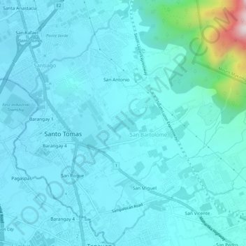
Name: San Miguel topographic map, elevation, terrain.
Average elevation: 653 ft
Minimum elevation: 387 ft
Maximum elevation: 2,949 ft
Other topographic maps
Click on a map to view its topography, its elevation and its terrain.
Santa Elena
Philippines > Batangas > Santo Tomas
Santa Elena, Santo Tomas, Batangas, Calabarzon, 4234, Philippines
Average elevation: 869 ft
San Vicente
Philippines > Batangas > Santo Tomas
San Vicente, Santo Tomas, Batangas, Calabarzon, 4234, Philippines
Average elevation: 1,010 ft
Santiago
Philippines > Batangas > Santo Tomas
Santiago, Santo Tomas, Batangas, Calabarzon, 4234, Philippines
Average elevation: 515 ft
San Bartolome
Philippines > Batangas > Santo Tomas
San Bartolome, Santo Tomas, Batangas, Calabarzon, 4234, Philippines
Average elevation: 810 ft
San Luis
Philippines > Batangas > Santo Tomas
San Luis, Santo Tomas, Batangas, Calabarzon, 4234, Philippines
Average elevation: 909 ft
Santa Clara
Philippines > Batangas > Santo Tomas > Santa Clara
Santa Clara, Santo Tomas, Batangas, Calabarzon, 4234, Philippines
Average elevation: 919 ft
San Joaquin
Philippines > Batangas > Santo Tomas > San Joaquin
San Joaquin, Santo Tomas, Batangas, Calabarzon, 4234, Philippines
Average elevation: 722 ft
San Antonio
Philippines > Batangas > Santo Tomas > San Antonio
San Antonio, Santo Tomas, Batangas, Calabarzon, 4234, Philippines
Average elevation: 659 ft
San Rafael
Philippines > Batangas > Santo Tomas
San Rafael, Santo Tomas, Batangas, Calabarzon, 4234, Philippines
Average elevation: 518 ft
Santa Cruz
Philippines > Batangas > Santo Tomas
Santa Cruz, Santo Tomas, Batangas, Calabarzon, 4234, Philippines
Average elevation: 1,355 ft
San Roque
Philippines > Batangas > Santo Tomas
San Roque, Santo Tomas, Batangas, Calabarzon, 4234, Philippines
Average elevation: 479 ft