
Lakhisarai topographic map
Interactive map
Click on the map to display elevation.
About this map
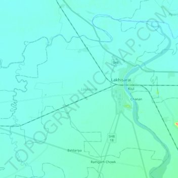
Name: Lakhisarai topographic map, elevation, terrain.
Location: Lakhisarai, Lakhisarai District, Bihar, India (25.09788 85.95570 25.23751 86.14373)
Average elevation: 148 ft
Minimum elevation: 112 ft
Maximum elevation: 545 ft
Other topographic maps
Click on a map to view its topography, its elevation and its terrain.
Samastipur
Samastipur, Samastipur District, Bihar, 848101, India
Average elevation: 157 ft
Kishanganj
Kishanganj, Madhepura District, Bihar, 852115, India
Average elevation: 128 ft
Pashchim Champāran
Pashchim Champāran, Pashchim Champaran, Bihar, India
Average elevation: 679 ft
Sultanganj
India > Bihar > Sultanganj
Sultanganj, Bhagalpur, Bihar, 813223, India
Average elevation: 125 ft
Patna
India > Bihar > Patna Rural
Patna, Patna Rural, Patna District, Bihar, 800001, India
Average elevation: 167 ft
Purnia
India > Bihar > Purnia East > Purnia
Purnia, Purnia East, Purnia district, Bihar, 854301, India
Average elevation: 125 ft