
Moval topographic map
Interactive map
Click on the map to display elevation.
About this map
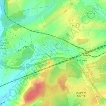
Name: Moval topographic map, elevation, terrain.
Average elevation: 1,201 ft
Minimum elevation: 1,112 ft
Maximum elevation: 1,309 ft
L’altitude moyenne de la commune est de 364 mètres.
Other topographic maps
Click on a map to view its topography, its elevation and its terrain.
Meroux
France > Bourgogne-Franche-Comté > Territoire-de-Belfort > Meroux-Moval
Meroux, Meroux-Moval, Belfort, Territoire-de-Belfort, Bourgogne-Franche-Comté, France métropolitaine, 90400, France
Average elevation: 1,204 ft