
Gilford topographic map
Interactive map
Click on the map to display elevation.
About this map
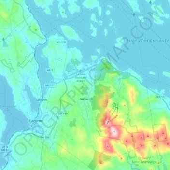
Name: Gilford topographic map, elevation, terrain.
Location: Gilford, Belknap County, New Hampshire, 03249, United States (43.48157 -71.45817 43.64057 -71.31150)
Average elevation: 758 ft
Minimum elevation: 479 ft
Maximum elevation: 2,362 ft
According to the United States Census Bureau, the town has a total area of 53.6 square miles (138.7 km2), of which 38.8 sq mi (100.5 km2) are land and 14.7 sq mi (38.2 km2) are water, comprising 27.56% of the town. Belknap Mountain, elevation 2,384 feet (727 m) above sea level and the highest point in Gilford as well as Belknap County, is in the south. Much of the town is drained by the Gunstock River, a tributary of Lake Winnipesaukee. Gilford lies fully within the Merrimack River watershed.
Other topographic maps
Click on a map to view its topography, its elevation and its terrain.
Winnisquam
United States > New Hampshire > Belknap County > Tilton
Winnisquam, Tilton, Belknap County, New Hampshire, 03289, United States
Average elevation: 574 ft
Glendale
United States > New Hampshire > Belknap County > Gilford
Glendale, Gilford, Belknap County, New Hampshire, 03249, United States
Average elevation: 594 ft
Weirs Beach
United States > New Hampshire > Belknap County > Laconia > Interlaken Park
Weirs Beach, Interlaken Park, Laconia, Belknap County, New Hampshire, 03247, United States
Average elevation: 587 ft
Lakeport
United States > New Hampshire > Belknap County > Laconia
Lakeport, Laconia, Belknap County, New Hampshire, 03246, United States
Average elevation: 591 ft
Squam Lake
United States > New Hampshire > Belknap County > Center Harbor
Squam Lake, Center Harbor, Belknap County, New Hampshire, United States
Average elevation: 722 ft
Hopkinson Hill
United States > New Hampshire > Belknap County > Sanbornton
Hopkinson Hill, Sanbornton, Belknap County, New Hampshire, 03269, United States
Average elevation: 958 ft
Meredith
United States > New Hampshire > Belknap County
Meredith, Belknap County, New Hampshire, 03253, United States
Average elevation: 705 ft
Lake Manning
United States > New Hampshire > Belknap County > Gilmanton
Lake Manning, Gilmanton, Belknap County, New Hampshire, United States
Average elevation: 814 ft
Sunset Lake
United States > New Hampshire > Belknap County > Alton
Sunset Lake, Alton, Belknap County, New Hampshire, United States
Average elevation: 879 ft
Laconia
United States > New Hampshire > Belknap County
Laconia, Belknap County, New Hampshire, United States
Average elevation: 666 ft
Sanbornton
United States > New Hampshire > Belknap County
Sanbornton, Belknap County, New Hampshire, 03269, United States
Average elevation: 748 ft
Governors Island
United States > New Hampshire > Belknap County > Gilford > Dockham Shore
Governors Island, Dockham Shore, Gilford, Belknap County, New Hampshire, United States
Average elevation: 531 ft
Alton
United States > New Hampshire > Belknap County
Alton, Belknap County, New Hampshire, United States
Average elevation: 771 ft
Lochmere
United States > New Hampshire > Belknap County > Belmont
Lochmere, Belmont, Belknap County, New Hampshire, 03252, United States
Average elevation: 568 ft
Adams Pond;Adams Pond Dam
United States > New Hampshire > Belknap County > Alton
Adams Pond;Adams Pond Dam, Alton, Belknap County, New Hampshire, 03809, United States
Average elevation: 827 ft
Gilmanton Ironworks
United States > New Hampshire > Belknap County > Gilmanton
Gilmanton Ironworks, Gilmanton, Belknap County, New Hampshire, 03837, United States
Average elevation: 735 ft
Gilmanton
United States > New Hampshire > Belknap County
Gilmanton, Belknap County, New Hampshire, United States
Average elevation: 843 ft
Welch Island
United States > New Hampshire > Belknap County > Gilford
Welch Island, Gilford, Belknap County, New Hampshire, United States
Average elevation: 502 ft
Gunstock Mountain
United States > New Hampshire > Belknap County > Gilford
Gunstock Mountain, Gilford, Belknap County, New Hampshire, 03249, United States
Average elevation: 1,496 ft
Center Harbor
United States > New Hampshire > Belknap County
Center Harbor, Belknap County, New Hampshire, United States
Average elevation: 702 ft
Yale Estates
United States > New Hampshire > Belknap County > Gilford > Yale Estates
Yale Estates, Gilford, Belknap County, New Hampshire, United States
Average elevation: 1,280 ft
Laconia
United States > New Hampshire > Belknap County > Laconia
Laconia, Belknap County, New Hampshire, 03246, United States
Average elevation: 745 ft
Winona
United States > New Hampshire > Belknap County > New Hampton > Winona
Winona, New Hampton, Belknap County, New Hampshire, United States
Average elevation: 761 ft
Tilton
United States > New Hampshire > Belknap County
Tilton, Belknap County, New Hampshire, United States
Average elevation: 643 ft
Center Barnstead
United States > New Hampshire > Belknap County > Barnstead
Center Barnstead, Barnstead, Belknap County, New Hampshire, 03218, United States
Average elevation: 600 ft
New Hampton
United States > New Hampshire > Belknap County
New Hampton, Belknap County, New Hampshire, 03256, United States
Average elevation: 866 ft
Belmont
United States > New Hampshire > Belknap County
Belmont, Belknap County, New Hampshire, United States
Average elevation: 761 ft
Belknap Mountain
United States > New Hampshire > Belknap County > Gilford
Belknap Mountain, Gilford, Belknap County, New Hampshire, 03249, United States
Average elevation: 1,634 ft
Alton Bay
United States > New Hampshire > Belknap County > Alton
Alton Bay, Alton, Belknap County, New Hampshire, 03809, United States
Average elevation: 741 ft