
Errol topographic map
Interactive map
Click on the map to display elevation.
About this map
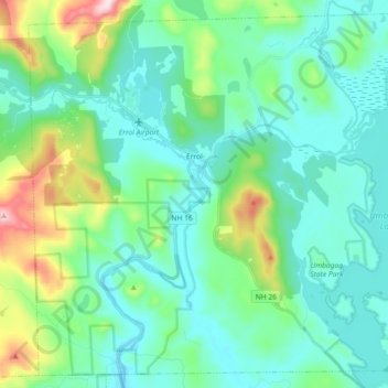
Name: Errol topographic map, elevation, terrain.
Location: Errol, Coös County, New Hampshire, United States (44.70826 -71.21592 44.82853 -71.03441)
Average elevation: 1,486 ft
Minimum elevation: 1,175 ft
Maximum elevation: 2,690 ft
According to the United States Census Bureau, the town has a total area of 69.5 square miles (179.9 km2), of which 60.3 square miles (156.3 km2) are land and 9.1 square miles (23.5 km2) are water, comprising 13.09% of the town. The Androscoggin River begins in Errol, where the Magalloway River joins the outlet of Umbagog Lake. The town's elevation reaches 2,350 feet (720 m) above sea level atop a bump above Signal Pond near the town's western boundary. Errol lies fully within the Androscoggin River watershed.
Other topographic maps
Click on a map to view its topography, its elevation and its terrain.
Mount Washington
United States > New Hampshire > Coos County
Mount Washington, Coös County, New Hampshire, United States
Average elevation: 5,144 ft
Northumberland
United States > New Hampshire > Coos County
Northumberland, Coös County, New Hampshire, United States
Average elevation: 1,257 ft
Stark
United States > New Hampshire > Coos County
Stark, Coös County, New Hampshire, United States
Average elevation: 1,726 ft
Shelburne
United States > New Hampshire > Coos County
Shelburne, Coös County, New Hampshire, United States
Average elevation: 1,532 ft
Groveton
United States > New Hampshire > Coos County
Groveton, Northumberland, Coös County, New Hampshire, United States
Average elevation: 997 ft
Columbia
United States > New Hampshire > Coos County
Columbia, Coös County, New Hampshire, United States
Average elevation: 1,814 ft
Dummer
United States > New Hampshire > Coos County
Dummer, Coös County, New Hampshire, United States
Average elevation: 1,375 ft
Twin Mountain
United States > New Hampshire > Coos County > Carroll
Twin Mountain, Carroll, Coös County, New Hampshire, 03595, United States
Average elevation: 1,608 ft
Pinkham Notch
United States > New Hampshire > Coos County
Pinkham Notch, Pinkham's Grant, Coös County, New Hampshire, United States
Average elevation: 2,516 ft
Milan
United States > New Hampshire > Coos County
Milan, Coös County, New Hampshire, 03588, United States
Average elevation: 1,470 ft
Stratford
United States > New Hampshire > Coos County
Stratford, Coös County, New Hampshire, 03590, United States
Average elevation: 1,631 ft
Castellated Ridge
United States > New Hampshire > Coos County
Castellated Ridge, Low and Burbank's Grant, Coös County, New Hampshire, United States
Average elevation: 3,543 ft
Lost Nation
United States > New Hampshire > Coos County > Northumberland
Lost Nation, Northumberland, Coös County, New Hampshire, United States
Average elevation: 1,191 ft
North Stratford
United States > New Hampshire > Coos County
North Stratford, Stratford, Coös County, New Hampshire, 03590, United States
Average elevation: 1,115 ft
Colebrook
United States > New Hampshire > Coos County
Colebrook, Coös County, New Hampshire, 03576, United States
Average elevation: 1,562 ft
Whitefield
United States > New Hampshire > Coos County
Whitefield, Coös County, New Hampshire, United States
Average elevation: 1,198 ft
Gorham
United States > New Hampshire > Coos County
Gorham, Coös County, New Hampshire, 03581, United States
Average elevation: 1,565 ft
Wildcat Mountain
United States > New Hampshire > Coos County
Wildcat Mountain, Coös County, New Hampshire, United States
Average elevation: 3,461 ft
Upper Kidderville
United States > New Hampshire > Coos County > Colebrook
Upper Kidderville, Colebrook, Coos County, New Hampshire, United States
Average elevation: 1,568 ft
Pittsburg
United States > New Hampshire > Coos County
Pittsburg, Coös County, New Hampshire, United States
Average elevation: 1,713 ft
Castle Mountain
United States > New Hampshire > Coos County
Castle Mountain, Coos County, New Hampshire, United States
Average elevation: 3,074 ft
Carroll
United States > New Hampshire > Coos County
Carroll, Coös County, New Hampshire, United States
Average elevation: 1,844 ft
Lancaster
United States > New Hampshire > Coos County
Lancaster, Coös County, New Hampshire, 03584, United States
Average elevation: 1,217 ft
Bretton Woods
United States > New Hampshire > Coos County > Carroll
Bretton Woods, Carroll, Coös County, New Hampshire, 03575, United States
Average elevation: 1,893 ft
Clarksville
United States > New Hampshire > Coos County
Clarksville, Coös County, New Hampshire, United States
Average elevation: 1,870 ft
Mount Crescent
United States > New Hampshire > Coos County
Mount Crescent, Coos County, New Hampshire, 03593, United States
Average elevation: 2,454 ft
Triple Falls
United States > New Hampshire > Coos County > Gorham
Triple Falls, Gorham, Coos County, New Hampshire, 03593, United States
Average elevation: 1,831 ft
Randolph
United States > New Hampshire > Coos County
Randolph, Coös County, New Hampshire, 03593, United States
Average elevation: 1,949 ft
LIttle Diamond Pond
United States > New Hampshire > Coos County > Stewartstown
LIttle Diamond Pond, Stewartstown, Coos County, New Hampshire, United States
Average elevation: 2,274 ft
Jefferson Highland
United States > New Hampshire > Coos County > Jefferson > Jefferson Highland
Jefferson Highland, Jefferson, Coos County, New Hampshire, 03583, United States
Average elevation: 1,480 ft
Jefferson
United States > New Hampshire > Coos County
Jefferson, Coös County, New Hampshire, 03583, United States
Average elevation: 1,617 ft
Dixville Notch
United States > New Hampshire > Coos County
Dixville Notch, Coos County, New Hampshire, United States
Average elevation: 2,149 ft
Stewartstown
United States > New Hampshire > Coos County
Stewartstown, Coös County, New Hampshire, 03597, United States
Average elevation: 1,591 ft
Dalton
United States > New Hampshire > Coos County
Dalton, Coös County, New Hampshire, United States
Average elevation: 1,230 ft
Mount Eisenhower
United States > New Hampshire > Coos County
Mount Eisenhower, Coos County, New Hampshire, 03589, United States
Average elevation: 3,747 ft