
Bhubaneshwar topographic map
Interactive map
Click on the map to display elevation.
About this map
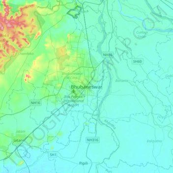
Name: Bhubaneshwar topographic map, elevation, terrain.
Average elevation: 98 ft
Minimum elevation: 20 ft
Maximum elevation: 653 ft
Bhubaneswar is in Khordha district of Odisha. It is in the eastern coastal plains, along the axis of the Eastern Ghats mountains. The city has an average altitude of 45 m (148 ft) above sea level. It lies southwest of the Mahanadi River that forms the northern boundary of Bhubaneswar metropolitan area, within its delta.
Other topographic maps
Click on a map to view its topography, its elevation and its terrain.
Bhubaneswar Municipal Corporation
India > Odisha > Bhubaneswar (M.Corp.) > Bhubaneswar Municipal Corporation
Bhubaneswar Municipal Corporation, Bhubaneswar (M.Corp.), Khordha, Odisha, India
Average elevation: 121 ft