
Waverley topographic map
Interactive map
Click on the map to display elevation.
About this map
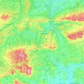
Name: Waverley topographic map, elevation, terrain.
Location: Waverley, Surrey, South East, England, United Kingdom (51.07150 -0.84893 51.24507 -0.41326)
Average elevation: 308 ft
Minimum elevation: 49 ft
Maximum elevation: 919 ft
Other topographic maps
Click on a map to view its topography, its elevation and its terrain.
Haslemere
United Kingdom > England > Waverley > Haslemere
Haslemere, Waverley, Surrey, South East, England, United Kingdom
Average elevation: 538 ft