
Banganga River topographic map
Interactive map
Click on the map to display elevation.
About this map
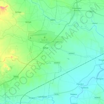
Name: Banganga River topographic map, elevation, terrain.
Location: Banganga River, Nashik, Maharashtra, 422001, India (20.05074 73.83208 20.12001 74.04754)
Average elevation: 1,916 ft
Minimum elevation: 1,745 ft
Maximum elevation: 2,657 ft
Other topographic maps
Click on a map to view its topography, its elevation and its terrain.
Raygad Udyan
India > Maharashtra > Nashik
Raygad Udyan, Nashik, Maharashtra, 422004, India
Average elevation: 1,982 ft
Pandav-Leni
India > Maharashtra > Nashik
Pandav-Leni, Nashik, Maharashtra, 422010, India
Average elevation: 2,119 ft
13
India > Maharashtra > Nashik > Pandav-Leni
13, Service Road, Ambad Gaon, Pandav-Leni, Nashik, Maharashtra, 422001, India
Average elevation: 2,152 ft
Nandur Madhyameshwar Dam
India > Maharashtra > Nashik
Nandur Madhyameshwar Dam, Nashik, Maharashtra, 422001, India
Average elevation: 1,742 ft
Shree Saptashrungi Udyan
India > Maharashtra > Nashik
Shree Saptashrungi Udyan, Nashik, Maharashtra, 422001, India
Average elevation: 1,942 ft