
Žabljak topographic map
Interactive map
Click on the map to display elevation.
About this map
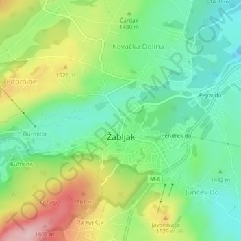
Name: Žabljak topographic map, elevation, terrain.
Location: Žabljak, Žabljak Municipality, Montenegro (43.14895 19.10998 43.16449 19.13694)
Average elevation: 4,793 ft
Minimum elevation: 4,521 ft
Maximum elevation: 5,262 ft
Other topographic maps
Click on a map to view its topography, its elevation and its terrain.
Pitomine
Montenegro > Žabljak Municipality
Pitomine, Žabljak Municipality, 84220, Montenegro
Average elevation: 4,944 ft