
Saint Stephen topographic map
Interactive map
Click on the map to display elevation.
About this map
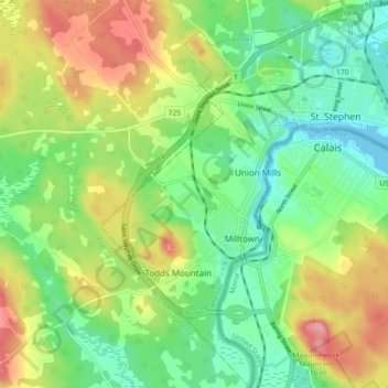
Name: Saint Stephen topographic map, elevation, terrain.
Location: Saint Stephen, Charlotte County, New Brunswick, Canada (45.14856 -67.33039 45.21269 -67.25827)
Average elevation: 144 ft
Minimum elevation: -7 ft
Maximum elevation: 371 ft
Other topographic maps
Click on a map to view its topography, its elevation and its terrain.
St. Stephen
Canada > New Brunswick > Charlotte County > St. Stephen
St. Stephen, Charlotte County, New Brunswick, E3L 2K2, Canada
Average elevation: 236 ft
Great Duck Island
Canada > New Brunswick > Charlotte County
Great Duck Island, Village of Grand Manan, Charlotte County, New Brunswick, Canada
Average elevation: 0 ft
Deer Island
Canada > New Brunswick > Charlotte County > Deer Island
Deer Island, West Isles Parish, Charlotte County, New Brunswick, E5V 1W2, Canada
Average elevation: 30 ft