
Kaprun topographic map
Interactive map
Click on the map to display elevation.
About this map
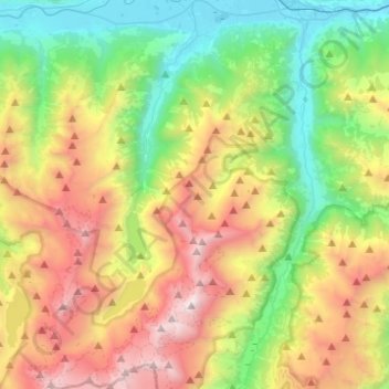
Name: Kaprun topographic map, elevation, terrain.
Location: Kaprun, Bezirk Zell am See, Salzburg, 5710, Austria (47.12070 12.66614 47.28834 12.79850)
Average elevation: 5,968 ft
Minimum elevation: 2,448 ft
Maximum elevation: 11,640 ft
The Kitzsteinhorn is accessed by the Gletscherbahn 1, an aerial lift in three sections, opened on 12 December 1965 to develop the area for glacier skiing. The lowest section, running from Kapruner Thoerl up to the Salzburg Hut, is 2028 metres long and climbs 970 metres in altitude. The second section, to the Krefeld Hut, climbs 554 metres. The third section, from the Krefeld Hut, is 2,192 metres (1.362 miles) long and climbs 575 metres. This section includes the world's tallest aerial lift pylon, a steel framework construction 113.9 metres (originally 106 meters) high. This pillar was built in 1966 and has of a pipe of 2.2 metres (7.2 feet) diameter in the center, in which a ladder and a maintenance elevator are installed.
Other topographic maps
Click on a map to view its topography, its elevation and its terrain.
Mittersill
Austria > Salzburg > Bezirk Zell am See
Mittersill, Bezirk Zell am See, Salzburg, 5730, Austria
Average elevation: 5,673 ft
Königsleiten
Austria > Salzburg > Bezirk Zell am See > Gemeinde Wald im Pinzgau
Königsleiten, Gemeinde Wald im Pinzgau, Bezirk Zell am See, Salzburg, 5742, Austria
Average elevation: 5,587 ft
Trattenbach
Austria > Salzburg > Bezirk Zell am See > Marktgemeinde Neukirchen am Großvenediger > Trattenbach
Trattenbach, Marktgemeinde Neukirchen am Großvenediger, Bezirk Zell am See, Salzburg, 5741, Austria
Average elevation: 3,737 ft
Zell am See
Austria > Salzburg > Bezirk Zell am See
Zell am See, Bezirk Zell am See, Salzburg, 5700, Austria
Average elevation: 3,668 ft
Leogang
Austria > Salzburg > Bezirk Zell am See
Leogang, Bezirk Zell am See, Salzburg, 5771, Austria
Average elevation: 3,881 ft