
Sierre topographic map
Interactive map
Click on the map to display elevation.
About this map
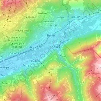
Name: Sierre topographic map, elevation, terrain.
Location: Sierre, Wallis, 3960, Switzerland (46.24568 7.42848 46.30711 7.58061)
Average elevation: 3,750 ft
Minimum elevation: 1,640 ft
Maximum elevation: 8,409 ft
The hilly topography of the valley floor derives from a very large postglacial rock avalanche, which collapsed from a fractured scar high to the north.
Other topographic maps
Click on a map to view its topography, its elevation and its terrain.
Corne de Sorebois
Switzerland > Wallis > Sierre > Anniviers
Corne de Sorebois, Route du Barrage, Anniviers, Sierre, Wallis, 3961, Switzerland
Average elevation: 7,887 ft
Montana
Switzerland > Wallis > Sierre > Crans-Montana
Montana, Crans-Montana, Sierre, Wallis, 3960, Switzerland
Average elevation: 4,039 ft
Le Bouillet
Switzerland > Wallis > Sierre > Anniviers > Zinal
Le Bouillet, Zinal, Anniviers, Sierre, Wallis, 3961, Switzerland
Average elevation: 7,110 ft
Vissoie
Switzerland > Wallis > Sierre > Anniviers
Vissoie, Anniviers, Sierre, Wallis, 3961, Switzerland
Average elevation: 5,246 ft
Crans-Montana
Switzerland > Wallis > Sierre
Crans-Montana, Sierre, Wallis, 3960, Switzerland
Average elevation: 5,446 ft
Crans
Switzerland > Wallis > Sierre > Crans-Montana > Crans
Crans, Crans-Montana, Sierre, Wallis, 3960, Switzerland
Average elevation: 4,636 ft