
Markowa topographic map
Interactive map
Click on the map to display elevation.
About this map
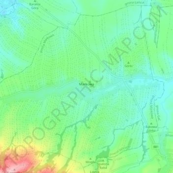
Name: Markowa topographic map, elevation, terrain.
Average elevation: 791 ft
Minimum elevation: 643 ft
Maximum elevation: 1,217 ft
Other topographic maps
Click on a map to view its topography, its elevation and its terrain.
Żołynia
Poland > Subcarpathian Voivodeship > Łańcut County
Żołynia, gmina Żołynia, Łańcut County, Subcarpathian Voivodeship, 37-110, Poland
Average elevation: 728 ft