
Bandipur topographic map
Interactive map
Click on the map to display elevation.
About this map
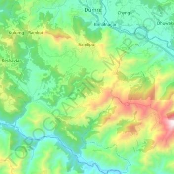
Name: Bandipur topographic map, elevation, terrain.
Location: Bandipur, Tanahun, Western Development Region, Nepal (27.84264 84.34647 27.97059 84.45789)
Average elevation: 2,421 ft
Minimum elevation: 758 ft
Maximum elevation: 6,739 ft
Bandipur is located at 27.56 N, 84.25 E and an elevation of 1030m on a mountain saddle (Mahabharat range) approximately 700m above the Marsyangdi River Valley, 143 km to the west of Kathmandu and 80 km to the east of Pokhara. Since 1998 it is connected by an 8 km access road from Dumre (Prithvi Highway). Until then there was only an unreliable road, in monsoon usually not accessible or only by tractors. The mountain saddle, just 200m long, is barely wide enough to accommodate the main street lined by 2 –3 storey buildings on either side. At the backsides of these houses the mountainsides steeply descend and the gardens are only accessible by stairs.