
Test Valley topographic map
Interactive map
Click on the map to display elevation.
About this map
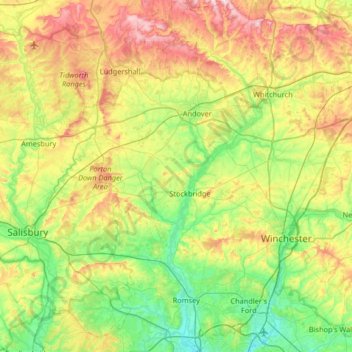
Name: Test Valley topographic map, elevation, terrain.
Location: Test Valley, Hampshire, South East, England, United Kingdom (50.92822 -1.69412 51.33936 -1.30883)
Average elevation: 318 ft
Minimum elevation: 0 ft
Maximum elevation: 932 ft
Other topographic maps
Click on a map to view its topography, its elevation and its terrain.
Barton Stacey
United Kingdom > England > Test Valley
Barton Stacey, Test Valley, Hampshire, South East, England, United Kingdom
Average elevation: 246 ft
Kimpton
United Kingdom > England > Test Valley
Kimpton, Test Valley, Hampshire, South East, England, United Kingdom
Average elevation: 364 ft
Chilworth
United Kingdom > England > Test Valley
Chilworth, Test Valley, Hampshire, South East, England, United Kingdom
Average elevation: 161 ft
Romsey
United Kingdom > England > Test Valley
Romsey, Test Valley, Hampshire, South East, England, United Kingdom
Average elevation: 82 ft