
Salland topographic map
Interactive map
Click on the map to display elevation.
About this map
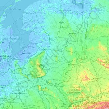
Name: Salland topographic map, elevation, terrain.
Average elevation: 72 ft
Minimum elevation: -26 ft
Maximum elevation: 1,237 ft
Other topographic maps
Click on a map to view its topography, its elevation and its terrain.
Luttenberg
Nederland > Overijssel > Luttenberg
Luttenberg, Raalte, Overijssel, Nederland, 8105 TZ, Nederland
Average elevation: 33 ft
Luttenberg
Nederland > Overijssel > Luttenberg
Luttenberg, Overijssel, Nederland, 8105, Nederland
Average elevation: 26 ft
Luttenberg
Nederland > Overijssel > Luttenberg
Luttenberg, Raalte, Overijssel, Nederland, 8105AV, Nederland
Average elevation: 33 ft