
Surrey Heath topographic map
Interactive map
Click on the map to display elevation.
About this map
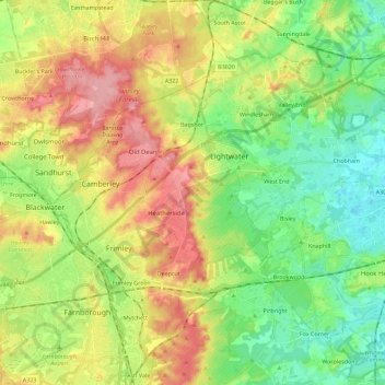
Name: Surrey Heath topographic map, elevation, terrain.
Location: Surrey Heath, Surrey, South East, England, United Kingdom (51.27925 -0.77548 51.39246 -0.54851)
Average elevation: 226 ft
Minimum elevation: 69 ft
Maximum elevation: 449 ft
Other topographic maps
Click on a map to view its topography, its elevation and its terrain.
Chobham
United Kingdom > England > Surrey Heath
Chobham, Surrey Heath, Surrey, South East, England, United Kingdom
Average elevation: 144 ft