
Harrison topographic map
Interactive map
Click on the map to display elevation.
About this map
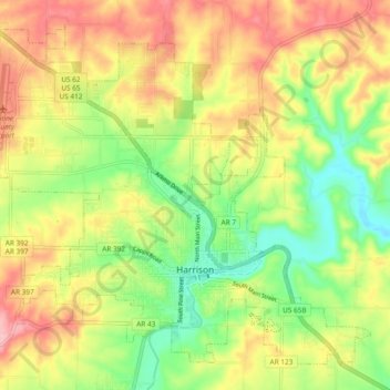
Name: Harrison topographic map, elevation, terrain.
Location: Harrison, Boone County, Arkansas, 72601, United States (36.21107 -93.15930 36.27756 -93.06517)
Average elevation: 1,217 ft
Minimum elevation: 984 ft
Maximum elevation: 1,467 ft
Other topographic maps
Click on a map to view its topography, its elevation and its terrain.
Olvey
United States > Arkansas > Boone County
Olvey, Boone County, Arkansas, United States
Average elevation: 1,109 ft
Omaha
United States > Arkansas > Boone County
Omaha, Boone County, Arkansas, 72662, United States
Average elevation: 1,280 ft
Valley Springs
United States > Arkansas > Boone County
Valley Springs, Boone County, Arkansas, 72601, United States
Average elevation: 1,132 ft
Batavia
United States > Arkansas > Boone County
Batavia, Boone County, Arkansas, United States
Average elevation: 1,493 ft
Diamond City
United States > Arkansas > Boone County
Diamond City, Boone County, Arkansas, 72630, United States
Average elevation: 732 ft
Zinc
United States > Arkansas > Boone County
Zinc, Boone County, Arkansas, 72601, United States
Average elevation: 1,063 ft
Bellefonte
United States > Arkansas > Boone County
Bellefonte, Boone County, Arkansas, 72601, United States
Average elevation: 1,115 ft
South Lead Hill
United States > Arkansas > Boone County
South Lead Hill, Boone County, Arkansas, 72644, United States
Average elevation: 797 ft
Bergman
United States > Arkansas > Boone County
Bergman, Boone County, Arkansas, 72601, United States
Average elevation: 1,260 ft
Alpena
United States > Arkansas > Boone County
Alpena, Boone County, Arkansas, 72611, United States
Average elevation: 1,224 ft
Capps
United States > Arkansas > Boone County
Capps, Boone County, Arkansas, United States
Average elevation: 1,424 ft
Everton
United States > Arkansas > Boone County
Everton, Boone County, Arkansas, 72633, United States
Average elevation: 958 ft
Lead Hill
United States > Arkansas > Boone County
Lead Hill, Boone County, Arkansas, United States
Average elevation: 1,004 ft