
Heppenheim topographic map
Interactive map
Click on the map to display elevation.
About this map
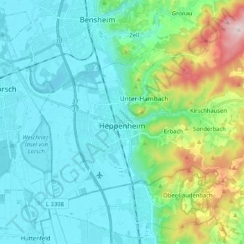
Name: Heppenheim topographic map, elevation, terrain.
Location: Heppenheim, Kreis Bergstraße, Hesse, 64646, Germany (49.60310 8.58889 49.68129 8.73108)
Average elevation: 581 ft
Minimum elevation: 292 ft
Maximum elevation: 1,749 ft
Other topographic maps
Click on a map to view its topography, its elevation and its terrain.
Reichenbach
Germany > Hesse > Kreis Bergstraße > Lautertal
Reichenbach, Lautertal, Kreis Bergstraße, Hesse, 64686, Germany
Average elevation: 1,030 ft