
Verghereto topographic map
Interactive map
Click on the map to display elevation.
About this map
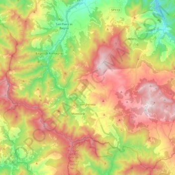
Name: Verghereto topographic map, elevation, terrain.
Average elevation: 2,769 ft
Minimum elevation: 1,050 ft
Maximum elevation: 4,557 ft
Other topographic maps
Click on a map to view its topography, its elevation and its terrain.
Montecoronaro
Italy > Emilia-Romagna > Verghereto
Montecoronaro, Verghereto, Unione dei comuni Valle del Savio, Forlì-Cesena, Emilia-Romagna, 47028, Italy
Average elevation: 3,100 ft