
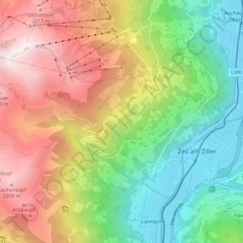
Gemeinde Zellberg topographic map
Interactive map
Click on the map to display elevation.
About this map
Name: Gemeinde Zellberg topographic map, elevation, terrain.
Location: Gemeinde Zellberg, Bezirk Schwaz, Tyrol, 6277, Austria (47.22265 11.80624 47.25831 11.88989)
Average elevation: 4,436 ft
Minimum elevation: 1,837 ft
Maximum elevation: 7,949 ft
Other topographic maps
Click on a map to view its topography, its elevation and its terrain.
Marktgemeinde Mayrhofen
Austria > Tyrol > Bezirk Schwaz
Marktgemeinde Mayrhofen, Bezirk Schwaz, Tyrol, Austria
Average elevation: 6,506 ft
Gemeinde Tux
Austria > Tyrol > Bezirk Schwaz
Gemeinde Tux, Bezirk Schwaz, Tyrol, Austria
Average elevation: 6,923 ft
Schwaz
Austria > Tyrol > Bezirk Schwaz
Schwaz, Stadt Schwaz, Bezirk Schwaz, Tyrol, 6130, Austria
Average elevation: 3,120 ft