
Guam topographic map
Interactive map
Click on the map to display elevation.
About this map
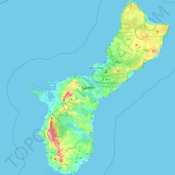
Name: Guam topographic map, elevation, terrain.
Location: Guam, Chalan Pago-Ordot Municipality, Guam, United States (13.24599 144.61832 13.65438 144.95696)
Average elevation: 85 ft
Minimum elevation: 0 ft
Maximum elevation: 1,266 ft
Other topographic maps
Click on a map to view its topography, its elevation and its terrain.
Mariana Islands
United States > Guam > Chalan Pago-Ordot Municipality
Mariana Islands, Chalan Pago-Ordot Municipality, Guam, United States
Average elevation: 0 ft