
VAM Berg topographic map
Interactive map
Click on the map to display elevation.
About this map
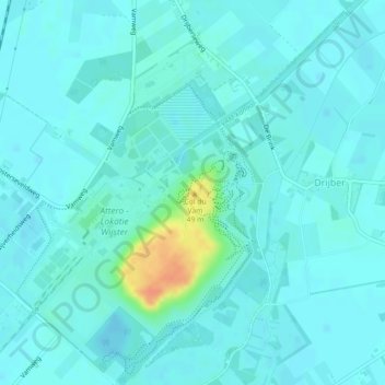
Name: VAM Berg topographic map, elevation, terrain.
Average elevation: 56 ft
Minimum elevation: 36 ft
Maximum elevation: 167 ft
Other topographic maps
Click on a map to view its topography, its elevation and its terrain.
Elp
Nederland > Drenthe > Midden-Drenthe
Elp, Midden-Drenthe, Drenthe, Nederland
Average elevation: 59 ft
Spier
Nederland > Drenthe > Midden-Drenthe
Spier, Midden-Drenthe, Drenthe, Nederland
Average elevation: 49 ft
Lieving
Nederland > Drenthe > Midden-Drenthe > Lieving
Lieving, Midden-Drenthe, Drenthe, Nederland, 9411, Nederland
Average elevation: 49 ft