
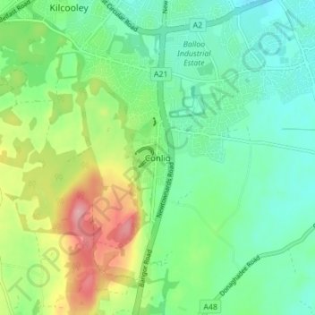
Conlig topographic map
Interactive map
Click on the map to display elevation.
About this map
Name: Conlig topographic map, elevation, terrain.
Average elevation: 197 ft
Minimum elevation: 69 ft
Maximum elevation: 466 ft
Other topographic maps
Click on a map to view its topography, its elevation and its terrain.
Cloghy
United Kingdom > Northern Ireland > County Down
Cloghy, County Down, Northern Ireland, BT22 1HY, United Kingdom
Average elevation: 26 ft
Ballymartin
United Kingdom > Northern Ireland > County Down > Ballymartin
Ballymartin, County Down, Northern Ireland, United Kingdom
Average elevation: 95 ft
Moira
United Kingdom > Northern Ireland > County Down
Moira, County Down, Northern Ireland, BT67 0LE, United Kingdom
Average elevation: 194 ft
Bangor
United Kingdom > Northern Ireland > County Down
Bangor, County Down, Northern Ireland, BT20 5AG, United Kingdom
Average elevation: 131 ft
Kernan Lake
United Kingdom > Northern Ireland > County Down
Kernan Lake, County Down, Northern Ireland, United Kingdom
Average elevation: 289 ft
Ballela
United Kingdom > Northern Ireland > County Down
Ballela, County Down, Northern Ireland, BT32 5PZ, United Kingdom
Average elevation: 446 ft
Drumaran Lake
United Kingdom > Northern Ireland > County Down > Gilford
Drumaran Lake, Gilford, County Down, Northern Ireland, United Kingdom
Average elevation: 213 ft
Lawrencetown
United Kingdom > Northern Ireland > County Down
Lawrencetown, County Down, Northern Ireland, BT63 6DU, United Kingdom
Average elevation: 236 ft
Loughbrickland
United Kingdom > Northern Ireland > County Down
Loughbrickland, County Down, Northern Ireland, BT32 3NH, United Kingdom
Average elevation: 318 ft
Greyabbey
United Kingdom > Northern Ireland > County Down
Greyabbey, County Down, Northern Ireland, BT22 2NE, United Kingdom
Average elevation: 59 ft
Drumaness
United Kingdom > Northern Ireland > County Down
Drumaness, County Down, Northern Ireland, BT24 8RL, United Kingdom
Average elevation: 243 ft
Dollingstown
United Kingdom > Northern Ireland > County Down
Dollingstown, County Down, Northern Ireland, United Kingdom
Average elevation: 184 ft
Bleary
United Kingdom > Northern Ireland > County Down > Bleary
Bleary, County Down, Northern Ireland, BT66 8TD, United Kingdom
Average elevation: 210 ft
Banbridge
United Kingdom > Northern Ireland > County Down
Banbridge, County Down, Northern Ireland, BT32 3DB, United Kingdom
Average elevation: 295 ft
Lough Erne
United Kingdom > Northern Ireland > County Down
Lough Erne, County Down, Northern Ireland, United Kingdom
Average elevation: 282 ft
Newtownards
United Kingdom > Northern Ireland > County Down
Newtownards, County Down, Ulster, Northern Ireland, BT23 4FA, United Kingdom
Average elevation: 164 ft
Dromara
United Kingdom > Northern Ireland > County Down
Dromara, County Down, Northern Ireland, BT25 2HX, United Kingdom
Average elevation: 489 ft
Stormont Estate
United Kingdom > Northern Ireland > County Down > Dundonald
Stormont Estate, Dundonald, County Down, Ulster, Northern Ireland, United Kingdom
Average elevation: 210 ft
Ballygowan
United Kingdom > Northern Ireland > County Down
Ballygowan, County Down, Ulster, Northern Ireland, BT23 6HB, United Kingdom
Average elevation: 220 ft
Groomsport
United Kingdom > Northern Ireland > County Down
Groomsport, County Down, Northern Ireland, BT19 6JR, United Kingdom
Average elevation: 33 ft
Dromore
United Kingdom > Northern Ireland > County Down
Dromore, County Down, Ulster, Northern Ireland, BT25 1BD, United Kingdom
Average elevation: 348 ft
Ballyroney
United Kingdom > Northern Ireland > County Down
Ballyroney, County Down, Ulster, Northern Ireland, United Kingdom
Average elevation: 279 ft
Seapatrick
United Kingdom > Northern Ireland > County Down > Banbridge
Seapatrick, Banbridge, County Down, Ulster, Northern Ireland, United Kingdom
Average elevation: 292 ft
Mourne Mountains Middle
United Kingdom > Northern Ireland > County Down
Mourne Mountains Middle, County Down, Northern Ireland, United Kingdom
Average elevation: 1,142 ft
Holywood
United Kingdom > Northern Ireland > County Down
Holywood, County Down, Northern Ireland, BT18 9AE, United Kingdom
Average elevation: 144 ft
Dundonald
United Kingdom > Northern Ireland > County Down
Dundonald, County Down, Northern Ireland, BT16 1RH, United Kingdom
Average elevation: 262 ft
Lagan Valley AONB
United Kingdom > Northern Ireland > County Down > Ballyskeagh
Lagan Valley AONB, Ballyskeagh, County Down, Ulster, Northern Ireland, United Kingdom
Average elevation: 217 ft
Ballycultra
United Kingdom > Northern Ireland > County Down > Holywood
Ballycultra, Holywood, County Down, Ulster, Northern Ireland, United Kingdom
Average elevation: 226 ft
Kilcoo
United Kingdom > Northern Ireland > County Down
Kilcoo, County Down, Northern Ireland, BT34 5HU, United Kingdom
Average elevation: 512 ft
Ardglass
United Kingdom > Northern Ireland > County Down
Ardglass, County Down, Ulster, Northern Ireland, BT31 9SZ, United Kingdom
Average elevation: 712 ft
Rathfriland
United Kingdom > Northern Ireland > County Down
Rathfriland, County Down, Ulster, Northern Ireland, BT34 5NH, United Kingdom
Average elevation: 318 ft
Killough
United Kingdom > Northern Ireland > County Down
Killough, County Down, Ulster, Northern Ireland, BT30 7QQ, United Kingdom
Average elevation: 23 ft
Gilford
United Kingdom > Northern Ireland > County Down
Gilford, County Down, Northern Ireland, BT63 6HH, United Kingdom
Average elevation: 141 ft
Scarva
United Kingdom > Northern Ireland > County Down
Scarva, County Down, Northern Ireland, BT63 6LS, United Kingdom
Average elevation: 184 ft
Katesbridge
United Kingdom > Northern Ireland > County Down
Katesbridge, County Down, Ulster, Northern Ireland, BT32 5PZ, United Kingdom
Average elevation: 325 ft
Scrabo Tower
United Kingdom > Northern Ireland > County Down > Newtownards
Scrabo Tower, Scrabo Road, Newtownards, County Down, Northern Ireland, BT23 4XP, United Kingdom
Average elevation: 128 ft
Burren River
United Kingdom > Northern Ireland > County Down > Castlewellan
Burren River, Castlewellan, County Down, Northern Ireland, BT31 9EB, United Kingdom
Average elevation: 279 ft
Newry
United Kingdom > Northern Ireland > County Down
Newry, County Down, Northern Ireland, United Kingdom
Average elevation: 240 ft
Slieve Donard
United Kingdom > Northern Ireland > County Down
Slieve Donard, County Down, Ulster, Northern Ireland, BT33 0HD, United Kingdom
Average elevation: 1,657 ft
Clonvaraghan
United Kingdom > Northern Ireland > County Down > Clonvaraghan
Clonvaraghan, County Down, Northern Ireland, BT31 9RH, United Kingdom
Average elevation: 410 ft
Kilkeel
United Kingdom > Northern Ireland > County Down
Kilkeel, County Down, Northern Ireland, BT34 4BH, United Kingdom
Average elevation: 115 ft
Blaris (Castlereagh Upper portion)
United Kingdom > Northern Ireland > County Down > Hillhall
Blaris (Castlereagh Upper portion), Hillhall, County Down, Northern Ireland, United Kingdom
Average elevation: 213 ft
Cherryvalley
United Kingdom > Northern Ireland > County Down > Comber
Cherryvalley, Comber, County Down, Northern Ireland, United Kingdom
Average elevation: 33 ft
Ardglass
United Kingdom > Northern Ireland > County Down > Ardglass
Ardglass, County Down, Northern Ireland, BT30 7SF, United Kingdom
Average elevation: 23 ft
Kinallen
United Kingdom > Northern Ireland > County Down
Kinallen, County Down, Northern Ireland, BT25 2PW, United Kingdom
Average elevation: 407 ft
Comber
United Kingdom > Northern Ireland > County Down
Comber, County Down, Northern Ireland, BT23 5DU, United Kingdom
Average elevation: 118 ft
Castlewellan
United Kingdom > Northern Ireland > County Down
Castlewellan, County Down, Ulster, Northern Ireland, BT31 9DQ, United Kingdom
Average elevation: 344 ft
Rostrevor
United Kingdom > Northern Ireland > County Down
Rostrevor, County Down, Northern Ireland, BT34 3AZ, United Kingdom
Average elevation: 256 ft
Warrenpoint
United Kingdom > Northern Ireland > County Down
Warrenpoint, County Down, Northern Ireland, BT34 3HS, United Kingdom
Average elevation: 335 ft
Moneyreagh
United Kingdom > Northern Ireland > County Down
Moneyreagh, County Down, Ulster, Northern Ireland, BT23 6BE, United Kingdom
Average elevation: 312 ft