
Changshou District topographic map
Interactive map
Click on the map to display elevation.
About this map
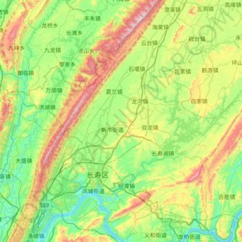
Name: Changshou District topographic map, elevation, terrain.
Location: Changshou District, Chongqing, China (29.71662 106.85738 30.22744 107.44042)
Average elevation: 1,316 ft
Minimum elevation: 443 ft
Maximum elevation: 3,465 ft
Other topographic maps
Click on a map to view its topography, its elevation and its terrain.
Apengjiang
Apengjiang, Qianjiang District, Chongqing, China
Average elevation: 2,795 ft
Youyang Miao and Tujia Autonomous County
Youyang Miao and Tujia Autonomous County, Chongqing, China
Average elevation: 2,398 ft
Lianglu
China > Chongqing > Yubei District > Lianglu
Lianglu, Yubei District, Chongqing Main City Metropolitan Area, Chongqing, 401120, China
Average elevation: 1,227 ft