
Grenagh topographic map
Interactive map
Click on the map to display elevation.
About this map
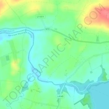
Name: Grenagh topographic map, elevation, terrain.
Average elevation: 118 ft
Minimum elevation: 46 ft
Maximum elevation: 266 ft
Other topographic maps
Click on a map to view its topography, its elevation and its terrain.
Shronowen
Shronowen, Shronowen ED, Listowel Municipal District, County Kerry, Munster, Ireland
Average elevation: 89 ft
Torc Mountain
Torc Mountain, Killarney Municipal District, County Kerry, Munster, V93 RR59, Ireland
Average elevation: 663 ft
Lisselton
Lisselton, Listowel Municipal District, County Kerry, Munster, Ireland
Average elevation: 112 ft
Farranfore
Farranfore, Tralee Municipal District, County Kerry, Munster, V93 YP44, Ireland
Average elevation: 194 ft
Stradbally Mountain
Stradbally Mountain, Kenmare Municipal District, County Kerry, Munster, Ireland
Average elevation: 1,598 ft
Glencar
Glencar, Kenmare Municipal District, County Kerry, Munster, Ireland
Average elevation: 374 ft
Cahersiveen
Cahersiveen, County Kerry, Munster, V23 FF95, Ireland
Average elevation: 217 ft
Kilgarvan
Kilgarvan, Kilgarvan ED, Kenmare Municipal District, County Kerry, Munster, Ireland
Average elevation: 233 ft
Brosna
Brosna, Tralee Municipal District, County Kerry, Munster, Ireland
Average elevation: 535 ft
Killarney
Killarney, Killarney Municipal District, County Kerry, Munster, Ireland
Average elevation: 187 ft
Rathmore
Rathmore, Rathmore ED, Killarney Municipal District, County Kerry, Munster, P51 PT66, Ireland
Average elevation: 489 ft
Lispole
Lispole, Kenmare Municipal District, County Kerry, Munster, V92 DN23, Ireland
Average elevation: 351 ft
Kilcummin
Kilcummin, Kilcummin ED, Killarney Municipal District, County Kerry, Munster, Ireland
Average elevation: 466 ft
Cromane Upper
Cromane Upper, Killorglin ED, Kenmare Municipal District, County Kerry, Munster, Ireland
Average elevation: 59 ft
Killorglin
Killorglin, Killorglin ED, Kenmare Municipal District, County Kerry, Munster, Ireland
Average elevation: 75 ft
Lyreboy
Lyreboy, Maum ED, Kenmare Municipal District, County Kerry, Munster, Ireland
Average elevation: 1,122 ft
Killarney
Killarney, Killarney Urban ED, Killarney Municipal District, County Kerry, Munster, Ireland
Average elevation: 128 ft
Glenmore
Glenmore, Glanmore ED, Kenmare Municipal District, County Kerry, Munster, Ireland
Average elevation: 883 ft
Glanmore
Glanmore, Kilgobban ED, Kenmare Municipal District, County Kerry, Munster, Ireland
Average elevation: 614 ft
Beheenagh
Beheenagh, Kilgobban ED, Kenmare Municipal District, County Kerry, Munster, Ireland
Average elevation: 1,138 ft
Banna Strand
Banna Strand, Banna ED, Tralee Municipal District, County Kerry, Munster, Ireland
Average elevation: 13 ft
Lauragh
Lauragh, Kenmare Municipal District, County Kerry, Munster, Ireland
Average elevation: 292 ft
Killarney
Ireland > County Kerry > Killarney
Killarney, Killarney Municipal District, County Kerry, Munster, V93 AYP9, Ireland
Average elevation: 217 ft
Glashanacree
Glashanacree, Kilshenane ED, Tralee Municipal District, County Kerry, Munster, Ireland
Average elevation: 469 ft
Derrybanane
Derrybanane, Flesk ED, Killarney Municipal District, County Kerry, Munster, Ireland
Average elevation: 981 ft
Valencia Island
Valencia Island, Kenmare Municipal District, County Kerry, Munster, Ireland
Average elevation: 128 ft
Barrow
Barrow, Ballynahaglish ED, Tralee Municipal District, County Kerry, Munster, Ireland
Average elevation: 23 ft
Lough Guitane
Lough Guitane, Flesk ED, Killarney Municipal District, County Kerry, Munster, Ireland
Average elevation: 367 ft
Knoppoge
Knoppoge, Ballyduff ED, Listowel Municipal District, County Kerry, Munster, Ireland
Average elevation: 95 ft
Gunsborough
Gunsborough, Gunsborough ED, Listowel Municipal District, County Kerry, Munster, V31 TR74, Ireland
Average elevation: 177 ft
Barraduff
Ireland > County Kerry > Barraduff
Barraduff, Killarney Municipal District, County Kerry, Munster, Ireland
Average elevation: 407 ft
Knocknacree
Knocknacree, Ballyduff ED, Listowel Municipal District, County Kerry, Munster, Ireland
Average elevation: 167 ft
Pallis
Pallis, Lahard ED, Killarney Municipal District, County Kerry, Munster, Ireland
Average elevation: 157 ft
Ballincolla
Ballincolla, Dunurlin ED, Kenmare Municipal District, County Kerry, Munster, Ireland
Average elevation: 72 ft
Rattoo Round Tower
Rattoo Round Tower, R551, Ballyduff ED, Listowel Municipal District, County Kerry, Munster, Ireland
Average elevation: 52 ft
Knockbrack
Knockbrack, Ballynorig ED, Listowel Municipal District, County Kerry, Munster, Ireland
Average elevation: 66 ft
Heirhill
Heirhill, Ballyheige ED, Listowel Municipal District, County Kerry, Munster, Ireland
Average elevation: 177 ft
Raheens
Raheens, Bahaghs ED, Kenmare Municipal District, County Kerry, Munster, Ireland
Average elevation: 545 ft
Ballintobernig
Ballintobernig, Ratass ED, Tralee Municipal District, County Kerry, Munster, Ireland
Average elevation: 597 ft
Castlelough
Castlelough, Muckross ED, Killarney Municipal District, County Kerry, Munster, V93 RR59, Ireland
Average elevation: 115 ft
Drombeg
Drombeg, Shronowen ED, Listowel Municipal District, County Kerry, Munster, Ireland
Average elevation: 141 ft
Knockglass Beg
Knockglass Beg, Knockglass ED, Kenmare Municipal District, County Kerry, Munster, Ireland
Average elevation: 308 ft
Ballydunlea
Ballydunlea, Tralee Rural ED, Tralee Municipal District, County Kerry, Munster, Ireland
Average elevation: 518 ft
Ballyconnell
Ballyconnell, Kilfeighny ED, Listowel Municipal District, County Kerry, Munster, Ireland
Average elevation: 135 ft
Coolroe Upper
Coolroe Upper, Glanbehy ED, Kenmare Municipal District, County Kerry, Munster, Ireland
Average elevation: 584 ft
Cahernageeha
Cahernageeha, Darrynane ED, Kenmare Municipal District, County Kerry, Munster, Ireland
Average elevation: 732 ft