
Izumo topographic map
Interactive map
Click on the map to display elevation.
About this map
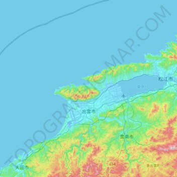
Name: Izumo topographic map, elevation, terrain.
Location: Izumo, Shimane Prefecture, Japan (35.16003 132.36459 35.71148 132.93441)
Average elevation: 272 ft
Minimum elevation: -13 ft
Maximum elevation: 2,493 ft
Izumo is located in central eastern of Shimane Prefecture. It has the second largest population in Shimane Prefecture after Matsue, and the third largest population in the San'in region after Matsue and Tottori. Centered on the Izumo Plain, the northern part of the city borders the Shimane Peninsula and the Sea of Japan, and the southern part borders the Chugoku Mountains. The Hii River flows through the eastern part of the city, and it empties into Lake Shinji. The city has a variety of topography, including the sea, mountains, rivers, lakes, plains, canyons, and hot springs.
Other topographic maps
Click on a map to view its topography, its elevation and its terrain.
Ozora
Ozora, Abashiri County, Okhotsk Subprefecture, Hokkaido Prefecture, Japan
Average elevation: 371 ft
Biratori
Biratori, Saru County, Hidaka Subprefecture, Hokkaido Prefecture, Japan
Average elevation: 607 ft
Toshima Island
Toshima Island, Maizuru, Kyoto Prefecture, Japan
Average elevation: 69 ft
Niseko
Niseko, Abuta County, Shiribeshi Subprefecture, Hokkaido Prefecture, Japan
Average elevation: 1,112 ft
Nichinan
Nichinan, Hino County, Tottori Prefecture, Japan
Average elevation: 1,906 ft
Noto
Noto, Houshi County, Ishikawa Prefecture, Chubu Region, Japan
Average elevation: 184 ft
Kitanakagusuku
Kitanakagusuku, Nakagami, Okinawa Prefecture, Japan
Average elevation: 194 ft
Watarase Usuichi
Watarase Usuichi, Tochigi, Tochigi Prefecture, 374-0112, Japan
Average elevation: 59 ft
Minakami
Minakami, Tone County, Gunma Prefecture, Japan
Average elevation: 3,350 ft
Saza
Saza, Kita-Matsuura County, Nagasaki Prefecture, 857-0322, Japan
Average elevation: 364 ft
Arita
Arita, Nishi-Matsuura County, Saga Prefecture, Japan
Average elevation: 604 ft
Sagara
Sagara, Kuma County, Kumamoto Prefecture, 868-0094, Japan
Average elevation: 1,385 ft
Nakaniikawa County
Nakaniikawa County, Toyama Prefecture, Chubu Region, Japan
Average elevation: 2,182 ft
Furuu County
Furuu County, Shiribeshi Subprefecture, Hokkaido Prefecture, Japan
Average elevation: 407 ft
Ashigarashimo County
Ashigarashimo County, Kanagawa Prefecture, Japan
Average elevation: 1,056 ft
Hakone
Hakone, Ashigarashimo County, Kanagawa Prefecture, Japan
Average elevation: 2,369 ft
Manazuru
Manazuru, Ashigarashimo County, Kanagawa Prefecture, 259-0201, Japan
Average elevation: 676 ft