
Sánchez Ramírez topographic map
Interactive map
Click on the map to display elevation.
About this map
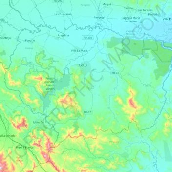
Name: Sánchez Ramírez topographic map, elevation, terrain.
Location: Sánchez Ramírez, Dominican Republic (18.84122 -70.37233 19.16605 -69.89459)
Average elevation: 446 ft
Minimum elevation: 36 ft
Maximum elevation: 2,844 ft
Other topographic maps
Click on a map to view its topography, its elevation and its terrain.
El 8
Dominican Republic > Sánchez Ramírez > Cotuí
El 8, Cotuí, Sánchez Ramírez, Dominican Republic
Average elevation: 564 ft
Cotuí
Dominican Republic > Sánchez Ramírez > Cotuí
Cotuí, Sánchez Ramírez, 430000, Dominican Republic
Average elevation: 341 ft
Cotuí
Dominican Republic > Sánchez Ramírez
Cotuí, Sánchez Ramírez, Dominican Republic
Average elevation: 456 ft