
Edirne topographic map
Interactive map
Click on the map to display elevation.
About this map
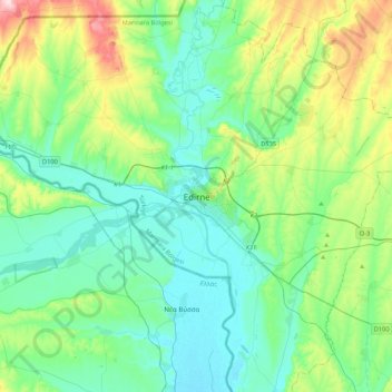
Name: Edirne topographic map, elevation, terrain.
Location: Edirne, Edirne Merkez, Edirne, Marmara Region, 22020, Turkey (41.51593 26.39872 41.83593 26.71872)
Average elevation: 302 ft
Minimum elevation: 85 ft
Maximum elevation: 1,037 ft
Other topographic maps
Click on a map to view its topography, its elevation and its terrain.
Karaağaç Mahallesi
Turkey > Edirne Merkez > Edirne
Karaağaç Mahallesi, Edirne, Edirne Merkez, Edirne, Marmara Region, Turkey
Average elevation: 135 ft