
Telford topographic map
Interactive map
Click on the map to display elevation.
About this map
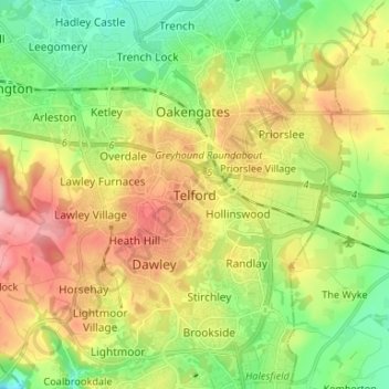
Name: Telford topographic map, elevation, terrain.
Location: Telford, Telford and Wrekin, England, TF3 4HB, United Kingdom (52.63804 -2.49143 52.71804 -2.41143)
Average elevation: 446 ft
Minimum elevation: 184 ft
Maximum elevation: 817 ft
Other topographic maps
Click on a map to view its topography, its elevation and its terrain.
Ironbridge
United Kingdom > England > Telford and Wrekin
Ironbridge, Telford and Wrekin, England, TF8 7AA, United Kingdom
Average elevation: 413 ft
Allscott
United Kingdom > England > Telford and Wrekin
Allscott, Wrockwardine, Telford and Wrekin, England, TF6 5EB, United Kingdom
Average elevation: 230 ft
Dawley
United Kingdom > England > Telford and Wrekin
Dawley, Telford and Wrekin, England, TF4 2TL, United Kingdom
Average elevation: 466 ft
Madeley
United Kingdom > England > Telford and Wrekin
Madeley, Telford and Wrekin, England, United Kingdom
Average elevation: 381 ft