
Flinders topographic map
Interactive map
Click on the map to display elevation.
About this map
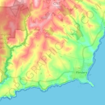
Name: Flinders topographic map, elevation, terrain.
Average elevation: 174 ft
Minimum elevation: 0 ft
Maximum elevation: 669 ft
Other topographic maps
Click on a map to view its topography, its elevation and its terrain.
Mount Eliza
Australia > Victoria > Melbourne
Mount Eliza, Melbourne, Shire of Mornington Peninsula, Victoria, 3930, Australia
Average elevation: 197 ft
Yarra Ranges National Park
Australia > Victoria > Melbourne
Yarra Ranges National Park, Reefton, Melbourne, Shire of Yarra Ranges, Victoria, Australia
Average elevation: 1,526 ft
Melbourne District
Australia > Victoria > Melbourne
Melbourne District, Melbourne, City of Melbourne, Victoria, Australia
Average elevation: 66 ft
Mornington District
Australia > Victoria > Melbourne
Mornington District, Melbourne, Shire of Mornington Peninsula, Victoria, Australia
Average elevation: 164 ft
Mount Martha
Australia > Victoria > Melbourne
Mount Martha, Melbourne, Shire of Mornington Peninsula, Victoria, 3934, Australia
Average elevation: 131 ft
Division of Kooyong
Australia > Victoria > Melbourne
Division of Kooyong, Melbourne, City of Boroondara, Victoria, Australia
Average elevation: 180 ft
Kingsville
Australia > Victoria > Melbourne
Kingsville, Melbourne, City of Maribyrnong, Victoria, 3012, Australia
Average elevation: 75 ft
Merricks North
Australia > Victoria > Melbourne
Merricks North, Melbourne, Shire of Mornington Peninsula, Victoria, 3926, Australia
Average elevation: 328 ft
Yarra Valley
Australia > Victoria > Melbourne
Yarra Valley, Melbourne, Shire of Yarra Ranges, Victoria, Australia
Average elevation: 1,001 ft
Point Cook
Australia > Victoria > Melbourne
Point Cook, Melbourne, City of Wyndham, Victoria, 3030, Australia
Average elevation: 26 ft
RMIT A'Beckett Urban Square
Australia > Victoria > Melbourne
RMIT A'Beckett Urban Square, Melbourne, City of Melbourne, Victoria, 3000, Australia
Average elevation: 102 ft
Ivanhoe East
Australia > Victoria > Melbourne
Ivanhoe East, Melbourne, City of Banyule, Victoria, 3079, Australia
Average elevation: 105 ft
Carlton North
Australia > Victoria > Melbourne
Carlton North, Melbourne, City of Yarra, Victoria, 3054, Australia
Average elevation: 135 ft
St Kilda East
Australia > Victoria > Melbourne
St Kilda East, Melbourne, City of Glen Eira, Victoria, 3183, Australia
Average elevation: 89 ft
Doncaster East
Australia > Victoria > Melbourne
Doncaster East, Melbourne, City of Manningham, Victoria, 3109, Australia
Average elevation: 292 ft
Northcote District
Australia > Victoria > Melbourne
Northcote District, Melbourne, City of Darebin, Victoria, Australia
Average elevation: 144 ft
Gladysdale
Australia > Victoria > Melbourne
Gladysdale, Melbourne, Shire of Yarra Ranges, Victoria, 3797, Australia
Average elevation: 892 ft
Endeavour Hills
Australia > Victoria > Melbourne
Endeavour Hills, Melbourne, City of Casey, Victoria, 3802, Australia
Average elevation: 223 ft
Bundoora District
Australia > Victoria > Melbourne
Bundoora District, Melbourne, City of Banyule, Victoria, Australia
Average elevation: 308 ft
Camberwell
Australia > Victoria > Melbourne
Camberwell, Melbourne, City of Boroondara, Victoria, 3124, Australia
Average elevation: 217 ft
Kilsyth South
Australia > Victoria > Melbourne
Kilsyth South, Melbourne, City of Maroondah, Victoria, 3137, Australia
Average elevation: 436 ft
Box Hill District
Australia > Victoria > Melbourne > Blackburn
Box Hill District, Guildford Road, Surrey Hills, City of Boroondara, Victoria, 3127, Australia
Average elevation: 289 ft
South Melbourne
Australia > Victoria > Melbourne
South Melbourne, Melbourne, City of Port Phillip, Victoria, 3205, Australia
Average elevation: 30 ft
Langwarrin
Australia > Victoria > Melbourne
Langwarrin, Melbourne, City of Frankston, Victoria, 3910, Australia
Average elevation: 233 ft
Maribyrnong
Australia > Victoria > Melbourne
Maribyrnong, Melbourne, City of Maribyrnong, Victoria, 3032, Australia
Average elevation: 75 ft
Melbourne Airport
Australia > Victoria > Melbourne
Melbourne Airport, Melbourne, City of Hume, Victoria, 3045, Australia
Average elevation: 344 ft
Burwood East
Australia > Victoria > Melbourne
Burwood East, Melbourne, City of Whitehorse, Victoria, 3151, Australia
Average elevation: 384 ft
Mount Evelyn
Australia > Victoria > Melbourne
Mount Evelyn, Melbourne, Shire of Yarra Ranges, Victoria, 3796, Australia
Average elevation: 620 ft