
Warsaw topographic map
Interactive map
Click on the map to display elevation.
About this map
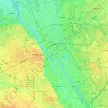
Name: Warsaw topographic map, elevation, terrain.
Location: Warsaw, Masovian Voivodeship, Poland (52.09785 20.85169 52.36815 21.27115)
Average elevation: 315 ft
Minimum elevation: 236 ft
Maximum elevation: 482 ft
Warsaw lies in east-central Poland about 300 km (190 mi) from the Carpathian Mountains and about 260 km (160 mi) from the Baltic Sea, 523 km (325 mi) east of Berlin, Germany. The city straddles the Vistula River. It is located in the heartland of the Masovian Plain, and its average elevation is 100 m (330 ft) above sea level. The highest point on the left side of the city lies at a height of 115.7 m (380 ft) ("Redutowa" bus depot, district of Wola), on the right side – 122.1 m (401 ft) ("Groszówka" estate, district of Wesoła, by the eastern border). The lowest point lies at a height 75.6 m (248 ft) (at the right bank of the Vistula, by the eastern border of Warsaw). There are some hills (mostly artificial) located within the confines of the city – e.g. Warsaw Uprising Hill (121 m (397 ft)) and Szczęśliwice hill (138 m (453 ft) – the highest point of Warsaw in general).
Other topographic maps
Click on a map to view its topography, its elevation and its terrain.
Warsaw
Poland > Masovian Voivodeship > Warsaw
Warsaw, Masovian Voivodeship, Poland
Average elevation: 312 ft
Piaseczno
Poland > Masovian Voivodeship > Piaseczno County
Piaseczno, gmina Piaseczno, Piaseczno County, Masovian Voivodeship, Poland
Average elevation: 354 ft
Pionki
Poland > Masovian Voivodeship > Radom County
Pionki, Radom County, Masovian Voivodeship, Poland
Average elevation: 522 ft
Gałki
Poland > Masovian Voivodeship > Sokołów County
Gałki, gmina Repki, Sokołów County, Masovian Voivodeship, 08-307, Poland
Average elevation: 476 ft
Wysokin
Poland > Masovian Voivodeship > Przysucha County
Wysokin, gmina Odrzywół, Przysucha County, Masovian Voivodeship, 26-425, Poland
Average elevation: 499 ft
Rajszew
Poland > Masovian Voivodeship > Legionowo County
Rajszew, gmina Jabłonna, Legionowo County, Masovian Voivodeship, 05-101, Poland
Average elevation: 259 ft
Kobyłka
Poland > Masovian Voivodeship > Wołomin County > Kobyłka
Kobyłka, Wołomin County, Masovian Voivodeship, Poland
Average elevation: 305 ft
Gradów
Poland > Masovian Voivodeship > Sochaczew County > Wikcinek
Gradów, Wikcinek, gmina Nowa Sucha, Sochaczew County, Masovian Voivodeship, 96-513, Poland
Average elevation: 299 ft
Syberia
Poland > Masovian Voivodeship > Mława County
Syberia, gmina Strzegowo, Mława County, Masovian Voivodeship, 06-522, Poland
Average elevation: 420 ft
Iłża
Poland > Masovian Voivodeship > Radom County
Iłża, gmina Iłża, Radom County, Masovian Voivodeship, 27-100, Poland
Average elevation: 669 ft
Pass
Poland > Masovian Voivodeship > Warsaw West County
Pass, gmina Błonie, Warsaw West County, Masovian Voivodeship, Poland
Average elevation: 292 ft
Rudniki
Poland > Masovian Voivodeship > Sokołów County
Rudniki, gmina Repki, Sokołów County, Masovian Voivodeship, 08-307, Poland
Average elevation: 413 ft
Maków Mazowiecki
Poland > Masovian Voivodeship > Maków County > Maków Mazowiecki
Maków Mazowiecki, Maków County, Masovian Voivodeship, 06-200, Poland
Average elevation: 344 ft
Wola Karczewska
Poland > Masovian Voivodeship > Otwock County
Wola Karczewska, gmina Wiązowna, Otwock County, Masovian Voivodeship, Poland
Average elevation: 400 ft
Cholewy
Poland > Masovian Voivodeship > Płońsk County
Cholewy, gmina Płońsk, Płońsk County, Masovian Voivodeship, Poland
Average elevation: 377 ft
Czerniaków
Poland > Masovian Voivodeship > Warsaw
Czerniaków, Mokotów, Warsaw, Masovian Voivodeship, Poland
Average elevation: 282 ft
Garwolin
Poland > Masovian Voivodeship > Garwolin
Garwolin, gmina Garwolin, Garwolin County, Masovian Voivodeship, 08-400, Poland
Average elevation: 453 ft
Zatopolice
Poland > Masovian Voivodeship > Radom County > Zatopolice
Zatopolice, gmina Zakrzew, Radom County, Masovian Voivodeship, Poland
Average elevation: 617 ft
Promnik
Poland > Masovian Voivodeship > Grójec County > Promnik
Promnik, gmina Nowe Miasto nad Pilicą, Grójec County, Masovian Voivodeship, Poland
Average elevation: 502 ft
Opole-Świerczyna
Poland > Masovian Voivodeship > Siedlce County > Opole-Świerczyna
Opole-Świerczyna, gmina Siedlce, Siedlce County, Masovian Voivodeship, 08-103, Poland
Average elevation: 476 ft
Serock
Poland > Masovian Voivodeship > Legionowo County > Serock > Serock
Serock, gmina Serock, Legionowo County, Masovian Voivodeship, 05-140, Poland
Average elevation: 302 ft
Taluba
Poland > Masovian Voivodeship > Garwolin County > Taluba
Taluba, gmina Garwolin, Garwolin County, Masovian Voivodeship, 08-400, Poland
Average elevation: 453 ft
Siedlce
Poland > Masovian Voivodeship > Siedlce County > Siedlce
Siedlce, Siedlce County, Masovian Voivodeship, Poland
Average elevation: 502 ft
Michałowice
Poland > Masovian Voivodeship > Grójec County
Michałowice, gmina Mogielnica, Grójec County, Masovian Voivodeship, Poland
Average elevation: 443 ft
Nuna
Poland > Masovian Voivodeship > Nowy Dwór Mazowiecki County > Nuna
Nuna, gmina Nasielsk, Nowy Dwór Mazowiecki County, Masovian Voivodeship, Poland
Average elevation: 358 ft
Narew
Poland > Masovian Voivodeship > Wyszków County > Stary Lubiel
Narew, Stary Lubiel, gmina Rząśnik, Wyszków County, Masovian Voivodeship, 07-207, Poland
Average elevation: 285 ft
Ożarów Mazowiecki
Poland > Masovian Voivodeship > Warsaw West County > Ożarów Mazowiecki
Ożarów Mazowiecki, gmina Ożarów Mazowiecki, Warsaw West County, Masovian Voivodeship, 05-850, Poland
Average elevation: 322 ft
Izabelin
Poland > Masovian Voivodeship > Płock County > Izabelin
Izabelin, gmina Brudzeń Duży, Płock County, Masovian Voivodeship, 09-414, Poland
Average elevation: 338 ft
Legionowo County
Legionowo County, Masovian Voivodeship, Poland
Average elevation: 289 ft
Otwock County
Otwock County, Masovian Voivodeship, Poland
Average elevation: 400 ft
Celejów
Poland > Masovian Voivodeship > Garwolin County
Celejów, gmina Wilga, Garwolin County, Masovian Voivodeship, 08-470, Poland
Average elevation: 325 ft
Wola Łącka
Poland > Masovian Voivodeship > Wola Łącka
Wola Łącka, gmina Łąck, Płock County, Masovian Voivodeship, 09-520, Poland
Average elevation: 341 ft
Leszno
Poland > Masovian Voivodeship > Leszno
Leszno, gmina Leszno, Warsaw West County, Masovian Voivodeship, 05-084, Poland
Average elevation: 295 ft
Mława County
Mława County, Masovian Voivodeship, Poland
Average elevation: 459 ft
Wołomin
Poland > Masovian Voivodeship > Wołomin County
Wołomin, gmina Wołomin, Wołomin County, Masovian Voivodeship, 05-200, Poland
Average elevation: 315 ft
Mińsk County
Mińsk County, Masovian Voivodeship, Poland
Average elevation: 469 ft
Radom County
Radom County, Masovian Voivodeship, Poland
Average elevation: 587 ft
Nasielsk
Poland > Masovian Voivodeship > Nasielsk
Nasielsk, gmina Nasielsk, Nowy Dwór Mazowiecki County, Masovian Voivodeship, 06-130, Poland
Average elevation: 377 ft
Sinołęka
Poland > Masovian Voivodeship > Mińsk County
Sinołęka, gmina Kałuszyn, Mińsk County, Masovian Voivodeship, Poland
Average elevation: 525 ft
Grądy
Poland > Masovian Voivodeship > Grądy
Grądy, gmina Sterdyń, Sokołów County, Masovian Voivodeship, 08-320, Poland
Average elevation: 433 ft
Rogóziec
Poland > Masovian Voivodeship > Rogóziec
Rogóziec, gmina Mordy, Siedlce County, Masovian Voivodeship, Poland
Average elevation: 548 ft
Sulejów
Poland > Masovian Voivodeship > Sulejów
Sulejów, gmina Jadów, Wołomin County, Masovian Voivodeship, Poland
Average elevation: 361 ft
Pilawa
Poland > Masovian Voivodeship > Pilawa
Pilawa, gmina Pilawa, Garwolin County, Masovian Voivodeship, 08-440, Poland
Average elevation: 486 ft
Szczutowo
Poland > Masovian Voivodeship > Szczutowo
Szczutowo, gmina Szczutowo, Sierpc County, Masovian Voivodeship, 09-227, Poland
Average elevation: 400 ft
Gleba
Poland > Masovian Voivodeship > Gleba
Gleba, gmina Kadzidło, Ostrołęka County, Masovian Voivodeship, 07-420, Poland
Average elevation: 374 ft
Wyszków County
Wyszków County, Masovian Voivodeship, Poland
Average elevation: 331 ft
Pruszków County
Pruszków County, Masovian Voivodeship, Poland
Average elevation: 381 ft
Ostrołęka
Ostrołęka, Masovian Voivodeship, Poland
Average elevation: 325 ft