
Richmond topographic map
Interactive map
Click on the map to display elevation.
About this map
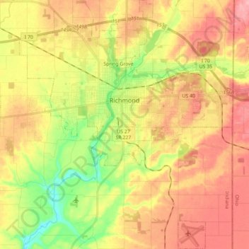
Name: Richmond topographic map, elevation, terrain.
Location: Richmond, Wayne County, Indiana, 47374, United States (39.74859 -84.96375 39.88259 -84.81367)
Average elevation: 1,030 ft
Minimum elevation: 810 ft
Maximum elevation: 1,220 ft
Other topographic maps
Click on a map to view its topography, its elevation and its terrain.
Spring Grove
United States > Indiana > Wayne County
Spring Grove, Wayne County, Indiana, United States
Average elevation: 984 ft
Boston
United States > Indiana > Wayne County
Boston, Wayne County, Indiana, 47324, United States
Average elevation: 1,129 ft
Cambridge City
United States > Indiana > Wayne County
Cambridge City, Wayne County, Indiana, United States
Average elevation: 958 ft
Economy
United States > Indiana > Wayne County
Economy, Wayne County, Indiana, United States
Average elevation: 1,132 ft
Hagerstown
United States > Indiana > Wayne County
Hagerstown, Wayne County, Indiana, United States
Average elevation: 1,024 ft