
Lima topographic map
Interactive map
Click on the map to display elevation.
About this map
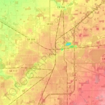
Name: Lima topographic map, elevation, terrain.
Location: Lima, Allen County, Ohio, 45804, United States (40.68766 -84.16510 40.79566 -84.07088)
Average elevation: 876 ft
Minimum elevation: 682 ft
Maximum elevation: 991 ft
Other topographic maps
Click on a map to view its topography, its elevation and its terrain.
Lima
United States > Ohio > Allen County
Lima, Allen County, Ohio, 45804, United States
Average elevation: 876 ft
Spencerville
United States > Ohio > Allen County
Spencerville, Allen County, Ohio, 45887, United States
Average elevation: 833 ft
Bluffton
United States > Ohio > Allen County
Bluffton, Allen County, Ohio, 45817, United States
Average elevation: 837 ft
Maysville
United States > Ohio > Allen County
Maysville, Jackson Township, Allen County, Ohio, United States
Average elevation: 1,007 ft
Kemp
United States > Ohio > Allen County
Kemp, Allen County, Ohio, United States
Average elevation: 840 ft
Landeck
United States > Ohio > Allen County
Landeck, Allen County, Ohio, United States
Average elevation: 794 ft
Scotts Crossing
United States > Ohio > Allen County
Scotts Crossing, Allen County, Ohio, United States
Average elevation: 784 ft
Hume
United States > Ohio > Allen County
Hume, Allen County, Ohio, United States
Average elevation: 853 ft
Gomer
United States > Ohio > Allen County
Gomer, Allen County, Ohio, 45809, United States
Average elevation: 778 ft
West Newton
United States > Ohio > Allen County
West Newton, Auglaize Township, Allen County, Ohio, United States
Average elevation: 1,037 ft
Southworth
United States > Ohio > Allen County
Southworth, Allen County, Ohio, United States
Average elevation: 810 ft
South Warsaw
United States > Ohio > Allen County
South Warsaw, Perry Township, Allen County, Ohio, United States
Average elevation: 928 ft
Rockport
United States > Ohio > Allen County
Rockport, Monroe Township, Allen County, Ohio, 45830, United States
Average elevation: 814 ft
Conant
United States > Ohio > Allen County
Conant, Allen County, Ohio, United States
Average elevation: 823 ft
Allentown
United States > Ohio > Allen County > Lima
Allentown, Lima, Allen County, Ohio, 45805, United States
Average elevation: 820 ft
Westminster
United States > Ohio > Allen County
Westminster, Auglaize Township, Allen County, Ohio, United States
Average elevation: 965 ft
Delphos
United States > Ohio > Allen County
Delphos, Allen County, Ohio, 45833, United States
Average elevation: 774 ft
Elida
United States > Ohio > Allen County
Elida, Allen County, Ohio, United States
Average elevation: 801 ft
Beaverdam
United States > Ohio > Allen County
Beaverdam, Allen County, Ohio, 45808, United States
Average elevation: 866 ft
Fort Shawnee
United States > Ohio > Allen County
Fort Shawnee, Allen County, Ohio, 45806, United States
Average elevation: 879 ft
Lafayette
United States > Ohio > Allen County
Lafayette, Allen County, Ohio, 45854, United States
Average elevation: 938 ft
Cairo
United States > Ohio > Allen County
Cairo, Allen County, Ohio, 45820, United States
Average elevation: 817 ft
Harrod
United States > Ohio > Allen County
Harrod, Allen County, Ohio, United States
Average elevation: 1,001 ft