
Marysvale topographic map
Interactive map
Click on the map to display elevation.
About this map
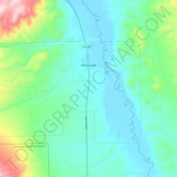
Name: Marysvale topographic map, elevation, terrain.
Location: Marysvale, Piute County, Utah, United States (38.41270 -112.31055 38.46065 -112.19869)
Average elevation: 6,325 ft
Minimum elevation: 5,810 ft
Maximum elevation: 8,678 ft
Other topographic maps
Click on a map to view its topography, its elevation and its terrain.
Junction
United States > Utah > Piute County
Junction, Piute County, Utah, 84740, United States
Average elevation: 6,204 ft
Circleville
United States > Utah > Piute County > Circleville
Circleville, Piute County, Utah, 84723, United States
Average elevation: 6,198 ft