
Xiashan District topographic map
Interactive map
Click on the map to display elevation.
About this map
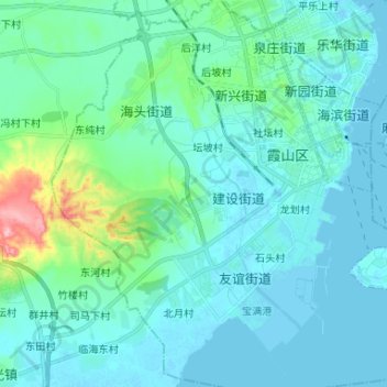
Name: Xiashan District topographic map, elevation, terrain.
Location: Xiashan District, Zhanjiang City, Guangdong, China (21.12049 110.31531 21.24295 110.44235)
Average elevation: 72 ft
Minimum elevation: -13 ft
Maximum elevation: 515 ft
Other topographic maps
Click on a map to view its topography, its elevation and its terrain.
Xinyi City
Xinyi City, Maoming City, Guangdong, 525300, China
Average elevation: 1,001 ft
Nanhu Sub-district
China > Guangdong > Shenzhen City > Nanhu Sub-district
Nanhu Sub-district, Luohu District, Shenzhen City, Guangdong, 518000, China
Average elevation: 95 ft